 Filter: Categories of Wisconsin Historical Images
Filter: Subject of Land
Filter: Subject of scandinavians
Filter: Categories of Wisconsin Historical Images
Filter: Subject of Land
Filter: Subject of scandinavians

| Date: | 06 29 1941 |
|---|---|
| Description: | A map showing the national roots of the people of Wisconsin, based on the ethnic stock research by University of Wisconsin-Madison sociologist Prof. George... |
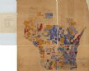
| Date: | 1890 |
|---|---|
| Description: | A hand-colored map of Wisconsin showing distribution ethnic groups based on the 1885 state census. The various nationalities are color-coded and include: I... |
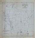
| Date: | 1905 |
|---|---|
| Description: | A map of showing the population density of foreign-born Scandinavians in Wisconsin based information from the 1905 census. The map also shows the county bo... |
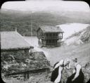
| Date: | |
|---|---|
| Description: | View of a mountaintop house and other buildings with sod roofs. Two women, who are possibly Swiss or Norwegian, are in the foreground sitting on a steep hi... |
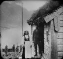
| Date: | |
|---|---|
| Description: | A farming couple pose together on the steps of a building with a sod roof in Nordfjord country. In the background is a lake and a mountain on the far shore... |
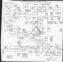
| Date: | 1971 |
|---|---|
| Description: | This map is a photocopy of a plat created in 1966 by Malcolm Rosholt which shows the community as it appeared in 1856. The map includes land owned by Norwe... |
If you didn't find the material you searched for, our Library Reference Staff can help.
Call our reference desk at 608-264-6535 or email us at: