 Filter: Categories of Wisconsin Historical Images
Filter: Subject of Land
Filter: Subject of real estate business
Filter: Categories of Wisconsin Historical Images
Filter: Subject of Land
Filter: Subject of real estate business
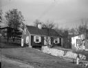
| Date: | 12 13 1949 |
|---|---|
| Description: | View of a house in the Crestwood neighborhood built by Jack Threlfall in a Madison shop and assembled on site. A sign in the front yard reads: "For Sale An... |
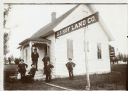
| Date: | |
|---|---|
| Description: | Six men in suits and hats, probably employees of J.J. Hof Land Co., in front of the company office building. |
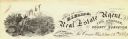
| Date: | |
|---|---|
| Description: | Letterhead of H.I. Bliss, a real estate agent, civil engineer, and county surveyor in La Crosse, Wisconsin. On the left a group of three men are surveying ... |

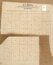
| Date: | 1903 |
|---|---|
| Description: | This map of Richland County, Wisconsin, shows land ownership and acreages, the township and range grid, sections, cities, towns and post offices, roads, ra... |
| Date: | |
|---|---|
| Description: | This 19th century manuscript map of the Town of Viroqua, Vernon County, Wisconsin, is drawn on a printed township grid. It shows landownership, roads, and ... |

| Date: | |
|---|---|
| Description: | Map shows roads, railroads, rivers, and improved farms. Includes text on lands for sale and exchange by B.W. Pulling, successor to Marshfield Land Company.... |

| Date: | 1910 |
|---|---|
| Description: | Shows land for sale by Rusk Farm Co. in Rusk and Chippewa Counties, as well as farmhouses, roads, and railroads. |

| Date: | 1915 |
|---|---|
| Description: | A pamphlet of lots for sale. There are four regions represented in four sheets of the pamphlet: "Mercer's Additions," "Edgewood Park," "West Lawn Heights,"... |

| Date: | 1890 |
|---|---|
| Description: | Shows plat of town, local streets, steam boat landings, and Chippewa River. Public square and Muskoo Island hand-colored. Map reads: "Full Lots are 125x66 ... |

| Date: | 1959 |
|---|---|
| Description: | This map includes directories, illustrations, and an inset location map and also covers Rock, Hog, Detroit and Plum islands. |

| Date: | 1970 |
|---|---|
| Description: | This map shows land owned by Menominee Enterprise Inc., land sold to Menominee shareholders, and land sold to non-Menominees. The map also includes water a... |
If you didn't find the material you searched for, our Library Reference Staff can help.
Call our reference desk at 608-264-6535 or email us at:
