 Filter: Categories of Wisconsin Historical Images
Filter: Subject of Land
Filter: Subject of public utilities
Filter: Categories of Wisconsin Historical Images
Filter: Subject of Land
Filter: Subject of public utilities
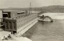
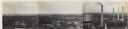
| Date: | 1925 |
|---|---|
| Description: | Elevated view of dam and power station on a river. Two automobiles are parked in a lot in the lower left corner. Bluffs are in the distance. |

| Date: | 12 16 1926 |
|---|---|
| Description: | Workmen with the City Line Department use an International Model 63 truck to erect a power line or telephone pole near a bridge. |
| Date: | 1920 |
|---|---|
| Description: | Exterior of the Eastman power plant. Two children pose on a metal cylinder outside the plant. The text on the photograph reads, "The Best electric light pl... |

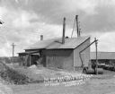
| Date: | |
|---|---|
| Description: | Three men posed standing on the porch of a small brick building with a tall smokestack, probably the City Water Pumping Station at Town Creek, surrounded b... |
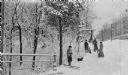
| Date: | 1910 |
|---|---|
| Description: | Four children pose in the snow with their sleds and a dachshund. There is a rustic bridge in the background and a railing in the left foreground. |
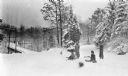
| Date: | 1910 |
|---|---|
| Description: | The photographer's four children pose with their sleds near Sheridan Road. There is a bridge over a ravine in the background and a blurred image of a dog i... |
| Date: | |
|---|---|
| Description: | Elevated view of hydroelectric plants on the Fox River. Caption reads: "Water Power - Looking West. Appleton, Wis." |
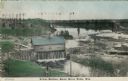
| Date: | 1908 |
|---|---|
| Description: | Colorized photographic postcard of an elevated view of the power station next to the river. A bridge is in the background. Caption reads: "Power Station, B... |
| Date: | 1930 |
|---|---|
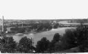
| Description: | Panoramic elevated view to the northeast from the Capitol Square. |

| Date: | 1894 |
|---|---|
| Description: | This map shows lot and block numbers, railroads, street car tracks, sewers, water mains, gas mains, paved streets, land owned by the Land & River Improveme... |

| Date: | |
|---|---|
| Description: | View across open area towards a brick power plant, where a man and a small dog are standing. Cords of wood are stacked at the left side of the building. On... |

| Date: | 08 13 1965 |
|---|---|
| Description: | H.O. Lord, Madison Metropolitan Sewerage District chief engineer, outlining the existing sewerage district on a map. Lord is trying to educate the public c... |

| Date: | 1973 |
|---|---|
| Description: | This map is 1 of 7 and includes a location map and township diagram in the margins. The map includes a key of land type: Residential (yellow), Commercial (... |

| Date: | 1973 |
|---|---|
| Description: | This map is 2 of 7 and includes a location map and township diagram in the bottom margin. The map includes a key of land type: Residential (yellow), Commer... |

| Date: | 1973 |
|---|---|
| Description: | This map is 3 of 7 and includes a location map and township diagram in the margins. The map includes a key of land type: Residential (yellow), Commercial (... |

| Date: | 1973 |
|---|---|
| Description: | This map is 4 of 7 and includes a location map and township diagram in the left margin. The map includes a key of land type: Residential (yellow), Commerci... |

| Date: | 1973 |
|---|---|
| Description: | This map is 5 of 7 and includes a location map and township diagram in the left margin. The map includes a key of land type: Residential (yellow), Commerci... |

| Date: | 1973 |
|---|---|
| Description: | This map is 6 of 7 and includes a location map and township diagram in the bottom margin. The map includes a key of land type: Residential (yellow), Commer... |

| Date: | 1973 |
|---|---|
| Description: | This map is 7 of 7 and includes a location map and township diagram in the left margin. The map includes a key of land type: Residential (yellow), Commerci... |

| Date: | |
|---|---|
| Description: | View across water towards the shoreline of the eastern isthmus of Madison, including the MG&E power plant smokestacks. A group of people appear to be fishi... |
If you didn't find the material you searched for, our Library Reference Staff can help.
Call our reference desk at 608-264-6535 or email us at: