 Filter: Categories of Wisconsin Historical Images
Filter: Subject of Land
Filter: Subject of plaques, plaquettes
Filter: Categories of Wisconsin Historical Images
Filter: Subject of Land
Filter: Subject of plaques, plaquettes
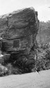
| Date: | 1920 |
|---|---|
| Description: | Van Hise Rock by Ableman's Narrows (Rock Springs), with dedication plaque. Rock Springs was called Ableman until 1947. |

| Date: | 1925 |
|---|---|
| Description: | The Pierre Pauquette monument located at the easterm terminus of the Wauona Trail. Erected by the Wau-bun Chapter of the Daughters of the American Revoluti... |
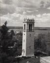
| Date: | 1948 |
|---|---|
| Description: | Elevated view from building of Carillon Tower on the University of Wisconsin-Madison campus. Lake Mendota and Picnic Point are in the background. There is ... |
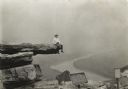
| Date: | 1905 |
|---|---|
| Description: | A small boy holding binoculars is sitting on the edge of Umbrella Rock, with a river far below. Below him is a plaque commemorating the Battle of Wauhatchi... |

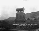
| Date: | |
|---|---|
| Description: | View of a large statue entitled, "The Hercules." The base includes a poem on a plaque. |

| Date: | 04 1902 |
|---|---|
| Description: | Confederate veterans at the Vicksburg Surrender Monument, on the occasion of decorating Union soldiers' graves. |
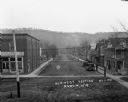
| Date: | 1921 |
|---|---|
| Description: | Elevated view of the central business district. The Avoca Cooperative Company is on the street corner on the left. Three men congregate near a car parked a... |
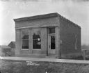
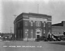
| Date: | 1909 |
|---|---|
| Description: | Exterior view of bank building with empty lots on either side. The wording on the door reads, "Banking Hours 9 to 4." A "Milwaukee Mechanics Insurance" sig... |
| Date: | 1931 |
|---|---|
| Description: | View from across street of schoolchildren standing and playing on the sidewalk outside the Benton High School. |

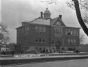
| Date: | 1924 |
|---|---|
| Description: | Exterior view of the Cameron High School. The building features three stories, a bell tower, and a flag pole. A home is in the distance. |
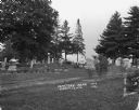
| Date: | 1921 |
|---|---|
| Description: | Rows of tombstones at the cemetery. The gravestone of Myrtle Schmelz is legible. |

| Date: | 1922 |
|---|---|
| Description: | Exterior of the Chaseburg Cooperative Creamery. Smoke comes from the back of the building. There is an advertisement for C.R. Watterson, "the painless dent... |

| Date: | 1922 |
|---|---|
| Description: | Exterior of the Chaseburg Cooperative Creamery and an attached secondary building. |

| Date: | 1912 |
|---|---|
| Description: | Exterior of the German Lutheran Church. The sign says "Deutsch Kirche." |
| Date: | 1922 |
|---|---|
| Description: | Monument dedicated to the first settlers of Coon Valley. The monument is in Norwegian. There is a cemetery in the distance. |
| Date: | 1929 |
|---|---|
| Description: | View from across street of the exterior of the First National Bank at 245 Main Street. Automobiles are parked at an angle along the curb in front. On the l... |
| Date: | 1928 |
|---|---|
| Description: | Way of the Cross station leading to St Anne's Shrine. Behind the shrine are birch and other trees and a view down the hill towards a valley. The station is... |

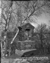
| Date: | |
|---|---|
| Description: | Plaque marker identifying the “Pioneer Military Road” route from Fort Howard at Green Bay to Fort Crawford at Prairie du Chien. |
If you didn't find the material you searched for, our Library Reference Staff can help.
Call our reference desk at 608-264-6535 or email us at:

