 Filter: Categories of Wisconsin Historical Images
Filter: Subject of Land
Filter: Subject of orchards
Filter: Categories of Wisconsin Historical Images
Filter: Subject of Land
Filter: Subject of orchards
| Date: | |
|---|---|
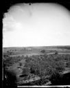
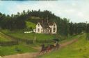
| Description: | Elevated view of a split-rail fence enclosing an orchard, with farmsteads and more fences in the distance. A man wearing a hat is posing with his hands on ... |
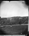
| Date: | 1873 |
|---|---|
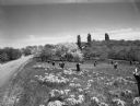
| Description: | A bearded man is standing in the foreground in front of a fence, and a person is sitting on the fence on the right. Two people are standing on the hill beh... |
| Date: | |
|---|---|
| Description: | Picnic Point from University drive, currently known as Observatory Hill. There are orchards in the foreground. |
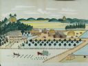
| Date: | 1875 |
|---|---|
| Description: | Seifert's watercolor is fairly large, measuring 27" wide by 21" high, and provides a detailed depiction of a nineteenth century Wisconsin farm. The small s... |
| Date: | 05 26 1950 |
|---|---|
| Description: | Apple orchard in blossom on the side of a road. There are a number of cut stumps in the foreground. A house is in the background among trees, and a watchto... |
| Date: | 1920 |
|---|---|
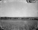
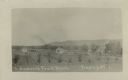
| Description: | A view of a rolling rural landscape, most likely in Sauk County. In the far distance are houses and farm buildings, a church and a larger building, center ... |
| Date: | 1910 |
|---|---|
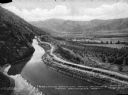
| Description: | View of an irrigation ditch near apple orchards in. Mountains are in the distance. Caption reads: Irrigation Ditch And Apple Orchards, Near Cashmere, Wash.... |

| Date: | |
|---|---|
| Description: | A view of a symmetrical rows of trees in an orchard on the plains. |
| Date: | |
|---|---|
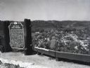
| Description: | Image of the historical marker for Gays Mills Apple Orchards overlooking the town of Gays Mills, Wisconsin. The marker stands to the left, leaving an eleva... |
| Date: | 1906 |
|---|---|
| Description: | This oil painting is a fine weave cotton support (perhaps a bed sheet). It is signed and dated (1906) and depicts an early twentieth century rural southwes... |
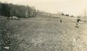
| Date: | 05 1911 |
|---|---|
| Description: | Stone walls line a tilled field where workers carry shovels and bundles of small trees to plant an orchard. |

| Date: | 1922 |
|---|---|
| Description: | View from hill of cherry trees in bloom in the Gibraltar Orchard on Sturgeon Bay Road (Highway 42.) |

| Date: | 05 25 1919 |
|---|---|
| Description: | The photographer's wife Clothilde admires the view of the Gibraltar Orchard in full bloom. The is a pile of lumber on the left; stones are piled under tree... |

| Date: | 1916 |
|---|---|
| Description: | This Wisconsin Conservation Commission map from 1916 shows Peninsula State Park in the Town of Gibraltar, Door County, Wisconsin. Depicted are open and pla... |

| Date: | 1916 |
|---|---|
| Description: | This version of a 1916 Wisconsin Conservation Commission map shows Peninsula State Park in the Town of Gibraltar, Door County, Wisconsin. Depicted are open... |

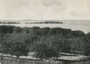
| Date: | 1930 |
|---|---|
| Description: | Aerial view over northern Door County, looking northeast across Europe Lake and Europe Bay toward Plum and Washington Islands. Farm fields and orchards con... |
| Date: | |
|---|---|
| Description: | Photographic postcard view of a slightly elevated view of the fruit ranch. Rows of crops in the foreground are bordered by a row of trees. Three dwellings ... |

| Date: | 1873 |
|---|---|
| Description: | A map of the township of Primrose from the "Atlas of Dane County." |

| Date: | 1873 |
|---|---|
| Description: | A map of the township of Montrose from the "Atlas of Dane County." |

| Date: | 1871 |
|---|---|
| Description: | This map shows buildings, roads, the railroad, an orchard, and swamp land. Relief shown by hachures. The map includes an index of buildings in the upper ri... |
If you didn't find the material you searched for, our Library Reference Staff can help.
Call our reference desk at 608-264-6535 or email us at: