 Filter: Categories of Wisconsin Historical Images
Filter: Subject of Land
Filter: Subject of municipal services
Filter: Categories of Wisconsin Historical Images
Filter: Subject of Land
Filter: Subject of municipal services
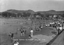
| Date: | 1930 |
|---|---|
| Description: | The municipal sand-bottomed swimming pool was a popular spot to cool off in the summer months. |
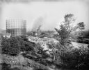
| Date: | 09 26 1906 |
|---|---|
| Description: | Menomonee Valley looking southeast from about N. 27th Street and W. St. Paul Avenue. A Milwaukee Gas Light Co. gas holder is on the left. |

| Date: | 1951 |
|---|---|
| Description: | Aerial view of Jones Island and garbage disposal plant. |

| Date: | 1950 |
|---|---|
| Description: | Harbor area of Jones Island and garbage disposal plant, Stratton Grain Co., and more. |
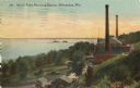
| Date: | 1910 |
|---|---|
| Description: | Elevated view from hill toward the building which has two large smokestacks. The Lake Michigan shoreline is on the left. In front is a landscaped area with... |

| Date: | |
|---|---|
| Description: | View of the Whiteface Mountain Highway Toll Station, and three cars parked nearby. |

| Date: | |
|---|---|
| Description: | Map of Baraboo and its surroundings, showing the ancient mound city, the water power, and thoroughfares, drawn by William H. Canfield. Canfield includes sk... |

| Date: | 1896 |
|---|---|
| Description: | Shows pipes of various sizes, hydrants with hydrant pressure, valves, wells, projected lines, and suction pipes. Differs from earlier versions by inclusion... |
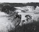
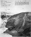
| Date: | 1963 |
|---|---|
| Description: | Sand and gravel pit used by the Dane County highway department as a source of supply. |

| Date: | 1894 |
|---|---|
| Description: | This map shows lot and block numbers, railroads, street car tracks, sewers, water mains, gas mains, paved streets, land owned by the Land & River Improveme... |

| Date: | 1920 |
|---|---|
| Description: | This map shows a plat of the area, numbered blocks and lots, local streets, roads, parks, Nakoma Country Club golf course, and landscaping. The map is orie... |
| Date: | 1940 |
|---|---|
| Description: | Two men are standing near the back of a Model D-15 owned by the City of Pasadena parked on the municipal golf course. The truck is used by the Park Departm... |
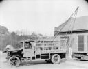
| Date: | 12 16 1926 |
|---|---|
| Description: | A man is sitting in the driver's seat of a truck. On the side of the truck is a sign that reads: "City Line Dep't." Equipment is hanging in the back of the... |
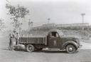
| Date: | 1950 |
|---|---|
| Description: | Subject: "I-4 — Material Handling." Where Taken: "NE." Information with photograph reads: "I-4 owned by City of Montpelier, Vermont. Used with Hough 1/2 ya... |
If you didn't find the material you searched for, our Library Reference Staff can help.
Call our reference desk at 608-264-6535 or email us at: