Filter: Categories of Wisconsin Historical Images
Filter: Subject of Land
Filter: Subject of mounds
Filter: Categories of Wisconsin Historical Images
Filter: Subject of Land
Filter: Subject of mounds

| Date: | 06 27 1927 |
|---|---|
| Description: | Aerial view of the effigy mound on Henry Wehmhoff's Riverview Farm. State Trunk Highway 83 runs through the effigy. |
| Date: | |
|---|---|
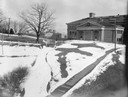
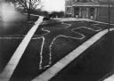
| Description: | A turtle effigy mound on the University of Wisconsin-Madison campus, outlined by melting snow. |
| Date: | 1905 |
|---|---|
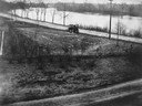
| Description: | View of an Indian intaglio effigy, the only one still in existence in Wisconsin. The effigy is in the shape of a panther. There is a car on the road in the... |
| Date: | |
|---|---|
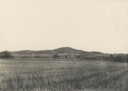
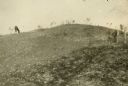
| Description: | Largest platform mound in Trempealeau as seen from the north. |
| Date: | |
|---|---|
| Description: | View of large platform mound with small barn in the foreground. The numbers 1, 2, and 3 are written on the photograph in ink. |
| Date: | |
|---|---|
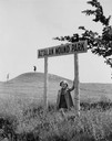
| Description: | Little girl under the "Aztalan Mound Park" sign, in a field. Another person stands in the background on one of the mounds. |
| Date: | 1945 |
|---|---|
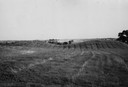
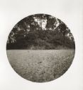
| Description: | Field with contours, and two mounds. |
| Date: | 1945 |
|---|---|
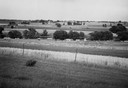
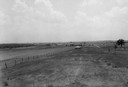
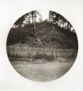
| Description: | Field prior to the park's reconstruction, with a fence in the foreground. A river is at the bottom of the hill. |
| Date: | |
|---|---|
| Description: | View of Aztalan State Park site when it was called Aztalan Mound Park. |
| Date: | |
|---|---|
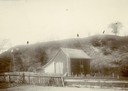
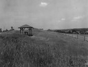
| Description: | Pavilion in the park is on left, with a fence along the right. |
| Date: | 1910 |
|---|---|
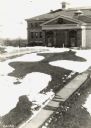
| Description: | Elevated view of a double-tailed turtle effigy mound on Observatory Hill on the University of Wisconsin-Madison campus. |
| Date: | 09 28 1942 |
|---|---|
| Description: | Elevated view of turtle mound on the University of Wisconsin-Madison campus. |
| Date: | 1914 |
|---|---|
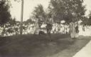
| Description: | Ceremony for erecting tablets on the Observatory Hill Mounds performed by University of Wisconsin summer session students. |
| Date: | 1909 |
|---|---|
| Description: | A horse grazes near Native American burial mounds on the Dividing Ridge, a recessional moraine, between Lakes Monona and Wingra in Madison, Wisconsin. The ... |

| Date: | 1859 |
|---|---|
| Description: | Map featuring various views of buildings and scenes from Sauk County. |

| Date: | 1828 |
|---|---|
| Description: | Plat of the Private Claims at Prairie Du Chien. |
| Date: | 05 11 1894 |
|---|---|
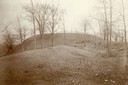
| Description: | South side view of an Indian Mound with a fence in front of it. |
| Date: | 05 11 1894 |
|---|---|
| Description: | East side view of an Indian Mound (Big Grave). |

| Date: | |
|---|---|
| Description: | Map of Baraboo and its surroundings, showing the ancient mound city, the water power, and thoroughfares, drawn by William H. Canfield. Canfield includes sk... |
If you didn't find the material you searched for, our Library Reference Staff can help.
Call our reference desk at 608-264-6535 or email us at: