 Filter: Categories of Wisconsin Historical Images
Filter: Subject of Land
Filter: Subject of locks (hydraulic engineering)
Filter: Categories of Wisconsin Historical Images
Filter: Subject of Land
Filter: Subject of locks (hydraulic engineering)
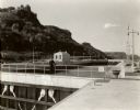
| Date: | 1935 |
|---|---|
| Description: | Locks on the Mississippi River, a nine foot channel. A man is standing above the locks. Bluffs are in the background. |
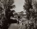
| Date: | 1910 |
|---|---|
| Description: | View looking down at the lock. Caption reads: "Fox River Near Little Chute, Wis." |
| Date: | 1935 |
|---|---|
| Description: | Elevated view of the Indian Agency House near the site of Fort Winnebago. View of Portage Canal in foreground. The canal was dug in 1849 as part of the Fox... |
| Date: | 1935 |
|---|---|
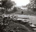
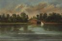
| Description: | A view of the Portage Canal and lock. The Indian Agency House in the center background. The canal was dug in 1849 as part of the Fox-Wisconsin waterway pro... |
| Date: | 1929 |
|---|---|
| Description: | A view of the canal locks on the Fox River. The Indian Agency House is in the background on a hill. |
| Date: | 10 11 1914 |
|---|---|
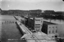
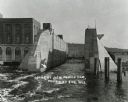
| Description: | Elevated view looking east across the power house, lock, and uncompleted portion of the dam. The concrete plant is seen on the far bank. The rising water o... |
| Date: | 02 28 1915 |
|---|---|
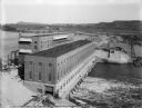
| Description: | Elevated view, looking east, of the power house, lock, and dam on the Wisconsin River. |
| Date: | 08 19 1915 |
|---|---|
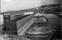
| Description: | Elevated view of the completed power house and dam, looking east at the north, or upstream, side of the structure. On the far shore, the site of the gravel... |
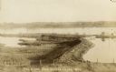
| Date: | 1913 |
|---|---|
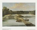
| Description: | Looking across water and through the locks to a shoreline with a large hill in the background. A building is on the left, a wall and pilings are in the wat... |

| Date: | 1856 |
|---|---|
| Description: | "The second view at the Kakalin, from the north side of the river, shows the first or guard lock in the foreground and beyond the dam the large frame build... |
| Date: | 1856 |
|---|---|
| Description: | "Three views in a short space show the peaceful appearance of what is now a busy paper mills center. The first, a double lock around which the village of C... |

| Date: | 1856 |
|---|---|
| Description: | "....The third view was twelve miles farther up the river [from De Pere], at Rapid Croche, on the border of the present Brown and Outagamie counties. It is... |

| Date: | 1856 |
|---|---|
| Description: | " . . . At Grand Chute stood the young settlement of Appleton. Although only a few years old, it already boasted a college, named, as was the village itsel... |

| Date: | 08 17 1874 |
|---|---|
| Description: | This manuscript drawing provides a side elevation, plan, and perspective view for a proposed lock on the Fox River. |

| Date: | 1892 |
|---|---|
| Description: | This map shows the dams and locks of the Fox River between Neenah, in Winnebago County, Wisconsin, and Kaukauna, in Outagamie County. The cities and villag... |

| Date: | 1868 |
|---|---|
| Description: | Map showing the northern water routes between Mississippi River and Atlantic Ocean Relief shown by hachures. Includes Profile of the Erie Canal, table of ... |

| Date: | 1875 |
|---|---|
| Description: | This map, from G.K. Warren's 1876 Report on the transportation route along the Wisconsin and Fox Rivers in the State of Wisconsin between the Mississippi R... |

| Date: | 1857 |
|---|---|
| Description: | This map shows lot and block numbers, streets, railroad depots, locks, bridges, dams, canals, U.S. light house, college grounds, a steam boat landing, and ... |

| Date: | 1790 |
|---|---|
| Description: | This map of the north eastern states shows roads, rivers, lakes, waterfalls, mountains, cities, forts, mills, the Oneida Reservation, and "New York Donatio... |
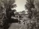
| Date: | |
|---|---|
| Description: | Lower locks on Grand Chute, Wisconsin, on the Fox River. |
If you didn't find the material you searched for, our Library Reference Staff can help.
Call our reference desk at 608-264-6535 or email us at: