 Filter: Categories of Wisconsin Historical Images
Filter: Subject of Land
Filter: Subject of flour mills
Filter: Categories of Wisconsin Historical Images
Filter: Subject of Land
Filter: Subject of flour mills
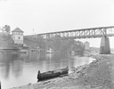
| Date: | |
|---|---|
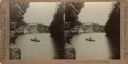
| Description: | View from shoreline, with a canoe in the foreground. Across the river on the opposite shoreline is the "Apollo No. 1" steamboat at Dells Landing, at Kilbou... |
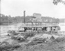
| Date: | |
|---|---|
| Description: | View down hill of the "Germania" steamboat along the shoreline in the foreground, across the river from bridge and Munger's Mill, which are in the backgrou... |
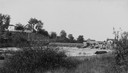
| Date: | 1900 |
|---|---|
| Description: | View from shoreline of Duncan Creek, a dam, and a flour mill. |
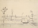
| Date: | 05 17 1849 |
|---|---|
| Description: | The Mill in Nodaway, Missouri; Sketched by Wilkins on his 151-day journey from Missouri to California on the Overland Trail (also known as the Oregon Trail... |

| Date: | 1895 |
|---|---|
| Description: | View of a mill, sluice and dam on Waumandee Creek. The mill was built by John Oschner in 1863. Two products produced by the mill were White Rose Flour and ... |
| Date: | 1900 |
|---|---|
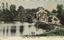
| Description: | View of the Lower Mill. Caption reads: "Lower Mill, Poynette, Wis." |
| Date: | 1940 |
|---|---|
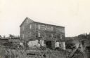
| Description: | Hadley Mill on the Little Platte River, seven miles southwest of Platteville in the Town of Paris. |
| Date: | 10 13 1911 |
|---|---|
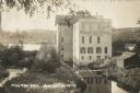
| Description: | Elevated view of a mill during a flood, with a man standing on the left between a bridge and the mill. A house is on the side of a tree-covered hill on the... |

| Date: | |
|---|---|
| Description: | View across wooden bridge to building identified as the Hixton Mill and Starch Factory on the edge of a body of water, probably a river. In the background ... |

| Date: | 1904 |
|---|---|
| Description: | A view of the mill and pond landscape of Sleepy Hollow. |

| Date: | 1871 |
|---|---|
| Description: | This map of Barron County, Wisconsin, shows the township and range grid, towns, sections, cities and villages, post offices, dwellings, schools, roads, swa... |

| Date: | 1858 |
|---|---|
| Description: | Map showing roads, mills, and rivers. Date conjectured from presence of Ensign’s Mill and Pitt’s Mill and location of Nekoosa. |
| Date: | 1909 |
|---|---|
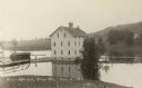
| Description: | Photographic postcard of an elevated view looking down at the Waterloo Roller Mills and Dam. Caption reads: "Mill and Dam, Waterloo, Wis." |

| Date: | 1851 |
|---|---|
| Description: | This map shows townships, villages, Indian villages, railroads, roads, mills, prairies, swamps, and canals. An inset map shows a plat of the copper distric... |

| Date: | |
|---|---|
| Description: | View across lawn and the Yahara River towards the Hausmann Brewing Company's Malt House in the center background. On the right is the Yahara River bridge. ... |
| Date: | |
|---|---|
| Description: | Stereograph of a man fishing from a rowboat in the millpond above Timme's Mill on Mirror Lake. The boat is framed by rock formations and tree on both sides... |
If you didn't find the material you searched for, our Library Reference Staff can help.
Call our reference desk at 608-264-6535 or email us at:
