 Filter: Categories of Wisconsin Historical Images
Filter: Subject of Land
Filter: Subject of floods
Filter: Categories of Wisconsin Historical Images
Filter: Subject of Land
Filter: Subject of floods
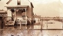
| Date: | 1918 |
|---|---|
| Description: | House surrounded by high water on Madeline Island. |

| Date: | 04 18 1965 |
|---|---|
| Description: | Wisconsin River in flood, looking downstream. |
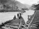
| Date: | 1919 |
|---|---|
| Description: | Men standing on the exposed portion of a flooded railroad track as a swiftly moving torrent of water is rushing past. Benham was a "company town" created b... |
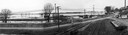
| Date: | 04 22 1965 |
|---|---|
| Description: | A panoramic view of the Mississippi River flooding during the spring, showing the dykes built along the Chicago, Burlington & Quincy Railroad tracks at Sec... |
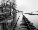
| Date: | 04 21 1965 |
|---|---|
| Description: | View down flooded railroad tracks of the Chicago, Burlington & Quincy Railroad by the Mississippi River. There are houses on the left, and in the backgroun... |
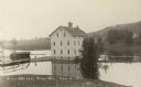
| Date: | 10 13 1911 |
|---|---|
| Description: | Elevated view of a mill during a flood, with a man standing on the left between a bridge and the mill. A house is on the side of a tree-covered hill on the... |
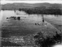
| Date: | 10 12 1911 |
|---|---|
| Description: | High water on the Wisconsin River has submerged the coffer dam and trestle. Two pile drivers remain in place. Log pilings are floating near the western sh... |
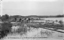
| Date: | 10 18 1911 |
|---|---|
| Description: | Workmen standing on damaged and partly submerged railroad track on the west shore of the Wisconsin River. |
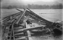
| Date: | 03 19 1913 |
|---|---|
| Description: | A view, looking east, of the wreckage of the high trestle caused by flooding and ice. The concrete plant is visible on the far bank. |
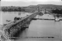
| Date: | 08 01 1912 |
|---|---|
| Description: | Elevated view of the power dam construction site from the west, showing the elevated trestle, coffer dam, and steam pile drivers. The concrete plant is vis... |

| Date: | 1926 |
|---|---|
| Description: | This hand-colored blueprint map shows landowners in part of T15N, R5E in Juneau County. North is oriented to the right. |
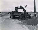
| Date: | 1941 |
|---|---|
| Description: | International TD-9 crawler tractor (TracTracTor) lifts dirt into a dump truck. Original caption reads: "An International TD-9 Diesel TracTracTor equipped w... |

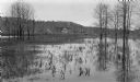
| Date: | 07 04 1960 |
|---|---|
| Description: | Landscape view of a flooded field at sunrise. |
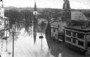
| Date: | |
|---|---|
| Description: | Elevated view of Second Street and surrounding area during a flood of the Ohio River. Some buildings are submerged up to their roof lines and the street re... |
| Date: | |
|---|---|
| Description: | Elevated view of a flood scene looking up Main Street showing Kellog-Hubbard Library, the stone building which opened in 1895, and churches. Men and women ... |

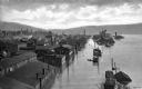
| Date: | |
|---|---|
| Description: | View across river of several houses and other buildings standing at the edge of the Chippewa River. One building has stilts supporting the back porch over ... |
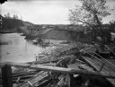
| Date: | 1903 |
|---|---|
| Description: | View of the wreckage of wooden structures lying on the shoreline of a river after a flood. A dam across the river has been partially washed away. A man is ... |
| Date: | 05 1916 |
|---|---|
| Description: | The Thorp house and barn are seen beyond a flooded low-lying area at the rear of the Vorous/Apfelbach farm at Fish Creek. The stone tower and buildings of ... |
If you didn't find the material you searched for, our Library Reference Staff can help.
Call our reference desk at 608-264-6535 or email us at:

