Filter: Categories of Wisconsin Historical Images
Filter: Subject of Land
Filter: Subject of express highways
Filter: Categories of Wisconsin Historical Images
Filter: Subject of Land
Filter: Subject of express highways

| Date: | 1965 |
|---|---|
| Description: | Front cover of an advertising brochure for International CO-4000 trucks with the "new top quality tilt-cab." Cover features color illustration of two deliv... |

| Date: | 1955 |
|---|---|
| Description: | Aerial view of La Crosse, with Onalaska in the background. The highway is U.S. Highway 53 and the State Highway 35. |

| Date: | 09 1962 |
|---|---|
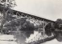
| Description: | The Mississippi River along Highway 35. |

| Date: | 1941 |
|---|---|
| Description: | Official highway map of Wisconsin, "the playground of the Midwest," showing the state transportation network prior to World War II. |

| Date: | 1955 |
|---|---|
| Description: | An aerial view of Mineral Point showing the construction of State Highway 23-39. |
| Date: | 1960 |
|---|---|
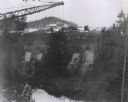
| Description: | Excavation for bridge column footings for the Mirror Lake Bridge. |
| Date: | 1960 |
|---|---|
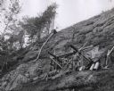
| Description: | View from below looking up towards workers constructing and reinforcing the forms for the footings of the interstate highway bridge at Mirror Lake. |

| Date: | 1960 |
|---|---|
| Description: | Aerial view of the construction of the interstate highway near Mirror Lake, showing only the early stages of the bridge construction. |
| Date: | 11 16 1960 |
|---|---|
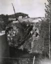
| Description: | Elevated view of the interstate highway bridge construction at Mirror Lake showing the concrete footings halfway down the embankment. |

| Date: | 1979 |
|---|---|
| Description: | Aerial view of Interstate I-90/94 at Camp Douglas, looking northwest. |

| Date: | 07 21 1972 |
|---|---|
| Description: | A section of the Wisconsin Interstate I-90/94 in Juneau County as most motorists know it - through the windshield. |
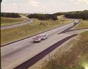
| Date: | 1965 |
|---|---|
| Description: | At many places in Wisconsin, the Interstate Highway is divided by a wide median strip that provides a scenic view for the motorist. This photograph shows ... |

| Date: | 1918 |
|---|---|
| Description: | "The playground of the Middle West." Showing the Numbered and Marked State Trunk Highway System and the Principal Secondary Highways; also locates Points o... |
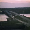
| Date: | 06 1977 |
|---|---|
| Description: | A view of the St. Croix River crossing at Hudson during the development of the Interstate Bridge. The old eastbound bridge seen here was built in 1951 whil... |

| Date: | 1913 |
|---|---|
| Description: | Wisconsin map showing fifteen hundred miles of national highways proposed by the National Highways Association. Scale: 1:2,500,000. These highways will dir... |
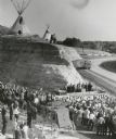
| Date: | 10 06 1961 |
|---|---|
| Description: | Dedication ceremony for a section of Interstate Highway I-90 near the Wisconsin Dells, with a group of Native Americans watching from above. A Dells Fargo ... |

| Date: | 1961 |
|---|---|
| Description: | View over beltline of University of Wisconsin-Madison Arboretum along Lake Wingra. Lake Mendota is on upper left, and Lake Monona is on the right, with the... |

| Date: | 09 26 1949 |
|---|---|
| Description: | A car drives down the western portion of the newly opened Madison belt line. The view is looking northwest in the region of Gilbert road (also Whitney Way)... |

| Date: | 1968 |
|---|---|
| Description: | Elevated view from steep hill of vehicles traveling on the tree-lined Henry Hudson Parkway. |
If you didn't find the material you searched for, our Library Reference Staff can help.
Call our reference desk at 608-264-6535 or email us at: