 Filter: Categories of Wisconsin Historical Images
Filter: Subject of Land
Filter: Subject of courthouses
Filter: Categories of Wisconsin Historical Images
Filter: Subject of Land
Filter: Subject of courthouses
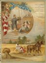
| Date: | 1894 |
|---|---|
| Description: | Color lithograph cover illustration for the McCormick Harvesting Machine Company catalog. Shows a courtroom scene framed with a draped American flag and th... |

| Date: | 1870 |
|---|---|
| Description: | Baraboo was first settled around 1838, and by 1870 it had become the county seat and the thriving village illustrated here. This birds eye drawing depicts ... |

| Date: | 1867 |
|---|---|
| Description: | Bird's-eye map of Green Bay and Fort Howard, Brown Co., depicts street names and street layouts, houses, trees, and the East River. A reference key at the ... |

| Date: | 1870 |
|---|---|
| Description: | Bird's-eye map of Hudson, with insets of Court House and Public School. |

| Date: | 1870 |
|---|---|
| Description: | Although the first European settlement in Jefferson was in 1836, the Village of Jefferson was first incorporated as a city in 1878. Made eight years earlie... |

| Date: | 1867 |
|---|---|
| Description: | Bird's-eye map of La Crosse with nine insets of residences, schools, and the Court House and Jail. |

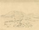
| Date: | 1852 |
|---|---|
| Description: | Pencil drawing of Madison landscape as seen from University Hill. The main street in the center is State Street, and the building with Greek columns in the... |

| Date: | 1883 |
|---|---|
| Description: | Bird's-eye map of Superior, county seat of Douglas County, on the shores of Lake Superior, with insets of points of interest. |

| Date: | 1875 |
|---|---|
| Description: | Bird's-eye map of Black River Falls, looking southwest. |
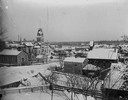
| Date: | 1890 |
|---|---|
| Description: | Elevated view of Main Street and the surrounding buildings. |

| Date: | 1920 |
|---|---|
| Description: | Elevated view of Whitehall from the Court House. A church is in the right foreground, and hills are in the distance. Caption at bottom reads: "Scene from C... |

| Date: | 1859 |
|---|---|
| Description: | Map featuring various views of buildings and scenes from Sauk County. |
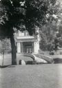
| Date: | 1935 |
|---|---|
| Description: | The entrance to the Marquette County Courthouse. |
| Date: | 1865 |
|---|---|
| Description: | Courthouse built in 1836, then torn down in 1871 to make way for a new structure. Tall central building with two wings coming off the sides. Path in fron... |

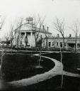
| Date: | 1870 |
|---|---|
| Description: | Slightly elevated view at an angle towards the left and front of the courthouse. A large statue is on top of the main dome. The area around the courthouse ... |
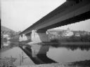
| Date: | |
|---|---|
| Description: | View from shoreline of a covered bridge over the Susquehannah River, with the Bradford county courthouse and other town buildings visible on the opposite s... |
| Date: | 1852 |
|---|---|
| Description: | Landscape featuring a rural city center with a prominent courthouse surrounded by fields and woods. Rolling erosion-softened mountains rise in the backgro... |

| Date: | |
|---|---|
| Description: | General view of the city, built into a hillside. The monumental building near the shore is the United States Courthouse, built in 1903. Published by Wint... |

| Date: | |
|---|---|
| Description: | General view of the city, built into a hillside. The monumental building near the shore is the United States Courthouse, built in 1903. Published by Winter... |
If you didn't find the material you searched for, our Library Reference Staff can help.
Call our reference desk at 608-264-6535 or email us at:
