 Filter: Categories of Wisconsin Historical Images
Filter: Subject of Land
Filter: Subject of cheese
Filter: Categories of Wisconsin Historical Images
Filter: Subject of Land
Filter: Subject of cheese

| Date: | 1918 |
|---|---|
| Description: | Map illlustrates creameries, condenseries and cheese factories in Wisconsin, January, 1918, and value of products. Five smaller maps in margin show changes... |

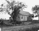
| Date: | 05 30 1964 |
|---|---|
| Description: | Landscape view from field of a rolling countryside. A small cheese factory resides on a slope, with a tree, a windmill, two cars and a tractor near an outb... |
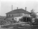
| Date: | 1922 |
|---|---|
| Description: | Exterior of a two-story cheese factory. The building features a set of stairs leading to the second-floor entrance and three chimneys. There is a large pil... |
| Date: | 1920 |
|---|---|
| Description: | View across dirt road of two men wearing overalls standing outside a rural cheese factory. There is a large, low wooden tub at the driveway entrance, and a... |

| Date: | 1928 |
|---|---|
| Description: | Shows different types of roads, railroads, schools, churches, farmsteads, cheese factories, mine shafts, old surface workings, streams, old sulphur pits, a... |
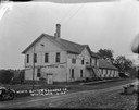
| Date: | 1925 |
|---|---|
| Description: | Three-quarter view of left side and front of the the Wiota Butter and Cheese Company. A wooden flight of stairs leads up to the second floor entrance. Ther... |
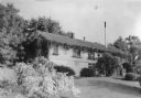
| Date: | 1940 |
|---|---|
| Description: | Shrubs in full bloom and a vigorous vine growing along the eaves create a picturesque view of a cheese factory. Typically, the long narrow building is buil... |
If you didn't find the material you searched for, our Library Reference Staff can help.
Call our reference desk at 608-264-6535 or email us at: