 Filter: Categories of Wisconsin Historical Images
Filter: Subject of Land
Filter: Subject of canals
Filter: Categories of Wisconsin Historical Images
Filter: Subject of Land
Filter: Subject of canals

| Date: | 1872 |
|---|---|
| Description: | Birds-eye drawing of Eau Claire depicts street names and street locations, houses, trees, bridges, piers, canals, railroads, and the Chippewa and Eau Clair... |

| Date: | 1892 |
|---|---|
| Description: | Bird's-eye map of Princeton, with an inset of the Residence of F.T. Yahr. Fox River loops to left of center, with one bridge; thirty-six businesses, reside... |
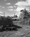
| Date: | 09 29 1963 |
|---|---|
| Description: | The Menasha Woodenware plant and water tower on Doty Island from across the Fox River canal, with a small railroad dolly in the foreground. |
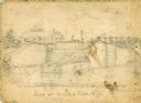
| Date: | 1856 |
|---|---|
| Description: | An original illustration of the lock at Rexford Flats. |

| Date: | |
|---|---|
| Description: | Plat map of the east central part of the city. |
| Date: | 1935 |
|---|---|
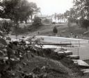
| Description: | Elevated view of the Indian Agency House near the site of Fort Winnebago. View of Portage Canal in foreground. The canal was dug in 1849 as part of the Fox... |
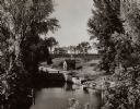
| Date: | 1935 |
|---|---|
| Description: | A view of the Portage Canal and lock. The Indian Agency House in the center background. The canal was dug in 1849 as part of the Fox-Wisconsin waterway pro... |

| Date: | 1945 |
|---|---|
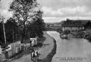
| Description: | An aerial view of the Portage Canal, Fox and Wisconsin Rivers. |
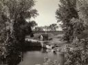
| Date: | 1929 |
|---|---|
| Description: | A view of the canal locks on the Fox River. The Indian Agency House is in the background on a hill. |
| Date: | 1849 |
|---|---|
| Description: | Map reads, "Map of the Western States". Published by Ensign & Thayer. There is a decorative vine border, and in each corner there is an engraving of four c... |

| Date: | 1839 |
|---|---|
| Description: | Map of a canal route to avoid the principal rapids of the Neenah or Fox River between Lake Winnebago and Green Bay. |

| Date: | 1837 |
|---|---|
| Description: | Map of the proposed route of the Milwaukee and Rock River Canal. |
| Date: | 1900 |
|---|---|
| Description: | Elevated view of a man with two mules on the left pulling a boat up the Chesapeake and Ohio Canal. A large wooden building is on the right bank in the behi... |
| Date: | |
|---|---|
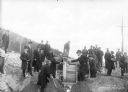
| Description: | A view of a group of men wearing long overcoats and hats, standing on rough ground. Two men in the center are shaking hands, and a few others are holding s... |

| Date: | 1847 |
|---|---|
| Description: | A color map of Kentucky with insets showing Lexington, the Falls of Ohio, and the Ohio River. |

| Date: | 06 1962 |
|---|---|
| Description: | Aerial view of old U.S. Army model H-21 helicopter, assigned to help Vietnamese forces fight the Viet Cong in the mountain region of Vietnam. The patchwork... |

| Date: | 1942 |
|---|---|
| Description: | This map shows the Wisconsin and Fox River routes in green, and the Milwaukee and Rock River Canal routes in red. Prairie du Chien, Fort Winnebago, Grand C... |

| Date: | 1853 |
|---|---|
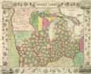
| Description: | Wisconsin counties by color and shows railroads, common roads, canals, the state capital, county towns, townships, villages, and post offices, |
If you didn't find the material you searched for, our Library Reference Staff can help.
Call our reference desk at 608-264-6535 or email us at:

