 Filter: Categories of Wisconsin Historical Images
Filter: Subject of Land
Filter: Subject of camp mccoy (wis.)
Filter: Categories of Wisconsin Historical Images
Filter: Subject of Land
Filter: Subject of camp mccoy (wis.)

| Date: | 1969 |
|---|---|
| Description: | A map of the Elroy-Sparta State Trail and the surrounding area, showing the townships, the towns of Cashton, Sparta, in the west, and Union Center and Elro... |

| Date: | 1940 |
|---|---|
| Description: | This maps shows the areas in Monroe, Jackson, and Juneau counties, Wisconsin, where U.S. Army maneuvers were held in August 1940. Highways and roads, commu... |
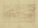
| Date: | 1931 |
|---|---|
| Description: | Top of the map reads: "SPECIAL MILITARY MAP 2626:2757:/27:2080:" and "Advance sheet, subject to correction." Bottom right of the map reads: "South Range gu... |
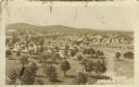
| Date: | |
|---|---|
| Description: | Elevated view of Fort McCoy with rows of tents among trees. There is a row of automobiles parked in the center, and a row of barracks on the left. Caption ... |
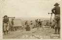
| Date: | |
|---|---|
| Description: | Photographic postcard view of a group of surveyors working on a hilltop at Camp McCoy. Caption reads: "O. P. Camp McCoy, Sparta, Wis." |
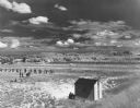
| Date: | 07 1949 |
|---|---|
| Description: | Elevated view of the Rifle Range at Camp McCoy during National Guard encampment of the 32nd Infantry Division. The soldiers are lined up in pairs on the le... |
If you didn't find the material you searched for, our Library Reference Staff can help.
Call our reference desk at 608-264-6535 or email us at: