Filter: Categories of Wisconsin Historical Images
Filter: Subject of Land
Filter: Subject of administrative agencies
Filter: Categories of Wisconsin Historical Images
Filter: Subject of Land
Filter: Subject of administrative agencies

| Date: | 1831 |
|---|---|
| Description: | Drawing of Fort Winnebago (near present-day Portage) that illustrated "Wau-Bun," Juliette Kinzie's memoir of her experiences on the early Wisconsin fronti... |
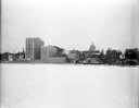
| Date: | 12 18 1955 |
|---|---|
| Description: | Downtown Madison lakeshore taken from Lake Monona in line with South Pinckney Street. Includes St. Raphael's steeple, 1 West Wilson Street state office bui... |
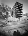
| Date: | 11 02 1930 |
|---|---|
| Description: | View of the State Office Building, 1 W. Wilson Street, under construction, from Lake Monona. The photographer's shadow and railroad tracks are in the foreg... |
| Date: | |
|---|---|
| Description: | Elevated view of grounds and buildings of the Pima Agency, near Phoenix. |
| Date: | 1935 |
|---|---|
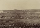
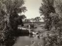
| Description: | Elevated view of the Indian Agency House near the site of Fort Winnebago. View of Portage Canal in foreground. The canal was dug in 1849 as part of the Fox... |
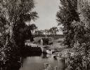
| Date: | 1935 |
|---|---|
| Description: | A view of the Portage Canal and lock. The Indian Agency House in the center background. The canal was dug in 1849 as part of the Fox-Wisconsin waterway pro... |
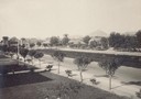
| Date: | 1929 |
|---|---|
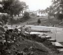
| Description: | A view of the canal locks on the Fox River. The Indian Agency House is in the background on a hill. |
| Date: | |
|---|---|
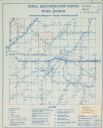
| Description: | Rural electrification map of Dodge county in Elba township. Title at top reads: "Rural Electrification Survey by Work Division of Wisconsin Emergency Relie... |

| Date: | 1883 |
|---|---|
| Description: | A hand-colored map of Wisconsin showing the nine congressional districts, it also shows the counties, cities, railroads, rivers, and lakes in the state. |

| Date: | 1845 |
|---|---|
| Description: | Wisconsin was considered part of Michigan Territory until 1836, a year before Michigan entered statehood. Drawn three years before Wisconsin entered stateh... |

| Date: | 1889 |
|---|---|
| Description: | Shows city limits, railroads, mills, schools, cemeteries, dams, parks, lumber yards, log canals, log reservoir, Chippewa River, Eau Claire River, and Half ... |

| Date: | 1960 |
|---|---|
| Description: | A hand-drawn map showing the "Negro Percentage of Each County's Population" in Mississippi. |
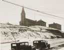
| Date: | 1934 |
|---|---|
| Description: | Terracing on Ellis Street during the winter. Two automobiles are parked alongside the road in the foreground. The terraced hill is snow covered, and a chur... |

| Date: | |
|---|---|
| Description: | Four men of the Wisconsin's Department of Natural Resources are wearing hard hats and standing next to a truck as they look over papers. The Wisconsin DNR ... |

| Date: | 1853 |
|---|---|
| Description: | A map of Wellfleet Harbor on Cape Cod Bay. |
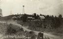
| Date: | |
|---|---|
| Description: | View towards a group of buildings across a road, housing state forestry offices, stables and storage. A watchtower is on a hill. Caption reads: "State Fore... |

| Date: | 07 14 1935 |
|---|---|
| Description: | Newspaper article in The Milwaukee Journal on Arville Schaleben and his coverage as a reporter/photographer on the colonists moving from Wisconsin a... |

| Date: | 12 18 1955 |
|---|---|
| Description: | Downtown Madison lakeshore taken from Lake Monona in a line with Monona Avenue. Includes State Office Building (2 wings only), 1 West Wilson Street, the Ma... |

| Date: | |
|---|---|
| Description: | In 1935, 202 families from the northern regions of Michigan, Wisconsin, and Minnesota were selected for this resettlement project, located near Palmer, Ala... |
If you didn't find the material you searched for, our Library Reference Staff can help.
Call our reference desk at 608-264-6535 or email us at: