 Filter: Categories of Wisconsin Historical Images
Filter: Subject of Land
Filter: County of Sauk
Filter: Categories of Wisconsin Historical Images
Filter: Subject of Land
Filter: County of Sauk
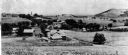
| Date: | 1903 |
|---|---|
| Description: | View down hill of the Enos Lloyd Jones farm with Hillside Home School and Romeo and Juliet in the background. |

| Date: | 1859 |
|---|---|
| Description: | Map featuring various views of buildings and scenes from Sauk County. |
| Date: | 1896 |
|---|---|
| Description: | Elevated view. Caption on negative sleeve reads: "Black Hawk Battlefield. Wis. Heights. 'Looking it of west across river' [sic] c. 1896. Mrs. Charle... |
| Date: | 1896 |
|---|---|
| Description: | Elevated view. Caption on negative sleeve reads: "Black Hawk Battlefield. Wis. Heights. Looking N. of E. up valley towards Catholic Church. Mrs. Charles N.... |
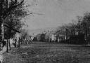
| Date: | 1875 |
|---|---|
| Description: | View of unpaved Water Street south of the Highway 12 intersection, looking north. Bluffs are in the distance. |
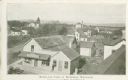
| Date: | 1900 |
|---|---|
| Description: | Elevated view of commercial buildings, houses, a church and a school in a neighborhood. In the foreground a person is standing at the side of a building wi... |

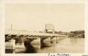
| Date: | 1925 |
|---|---|
| Description: | View down center of the Wisconsin River bridge. |
| Date: | 1925 |
|---|---|
| Description: | View across water along the right side of the Sauk City bridge, erected in 1922 to replace an old toll bridge. tree-covered hills are on the opposite shore... |
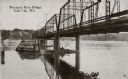
| Date: | 1910 |
|---|---|
| Description: | View from below along the left side of the Wisconsin River bridge. Tree-covered hills are on the opposite shoreline. Caption reads: "Wisconsin River Bridge... |
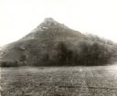
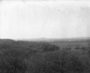
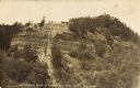
| Date: | 1896 |
|---|---|
| Description: | View of Black Hawk Bluff, site of the Battle of Wisconsin Heights in the Black Hawk War. |

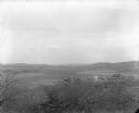
| Date: | 1895 |
|---|---|
| Description: | Elevated view of multiple homes and buildings. Hills are in the distance. |
| Date: | 1930 |
|---|---|
| Description: | View of the mill dam on Dell Creek that creates Mirror Lake in Mirror Lake State Park (although the photograph was taken before the site was designated as ... |
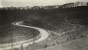
| Date: | 1920 |
|---|---|
| Description: | Loganville Road in Sauk County taken by the Wisconsin Good Roads Association. The photograph was meant to create a contrast between the new improved road ... |
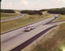
| Date: | 1965 |
|---|---|
| Description: | At many places in Wisconsin, the Interstate Highway is divided by a wide median strip that provides a scenic view for the motorist. This photograph shows ... |
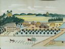
| Date: | 1875 |
|---|---|
| Description: | Seifert's watercolor is fairly large, measuring 27" wide by 21" high, and provides a detailed depiction of a nineteenth century Wisconsin farm. The small s... |
| Date: | 1907 |
|---|---|
| Description: | View of bluff taken from below. Caption reads: "Rattlesnake Bluff at Loddes Mill Sauk Co., Wis." |
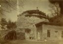
| Date: | 1890 |
|---|---|
| Description: | Old Uncle Billy Johnson home at Governor Phillip's house, about six miles north of Prairie du Sac near highway 12. Portion of house, rock formation in back... |
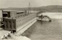
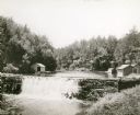
| Date: | 1925 |
|---|---|
| Description: | Elevated view of dam and power station on a river. Two automobiles are parked in a lot in the lower left corner. Bluffs are in the distance. |
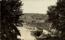
| Date: | 1908 |
|---|---|
| Description: | Elevated view from shoreline of toll bridge across the Wisconsin River. Caption reads: "A Glimpse of Pr-Du-Sac Toll Bridge." |
If you didn't find the material you searched for, our Library Reference Staff can help.
Call our reference desk at 608-264-6535 or email us at:
