 Filter: Categories of Wisconsin Historical Images
Filter: Subject of Land
Filter: County of Portage
Filter: Categories of Wisconsin Historical Images
Filter: Subject of Land
Filter: County of Portage

| Date: | 1891 |
|---|---|
| Description: | Bird's-eye map of Stevens Point, looking east, with an inset of the Water Works. Wisconsin River in foreground with fifty-three business locations identifi... |

| Date: | |
|---|---|
| Description: | Individuals use rowboats near the shore of Marlin's Island on the Wisconsin River. |

| Date: | |
|---|---|
| Description: | View of a sandbar crowded with trees in the Wisconsin River. |
| Date: | |
|---|---|
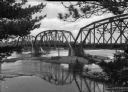
| Description: | Elevated view from shoreline toward construction workers standing on the Soo Line Railroad Bridge over the Wisconsin River. |

| Date: | |
|---|---|
| Description: | View from rocky shoreline toward trees along the opposite riverbank of the Wisconsin River. |

| Date: | |
|---|---|
| Description: | View of an island crowded with trees. Buildings are along the shore beyond the island. |

| Date: | |
|---|---|
| Description: | This map from the early 20th century shows the township and range grid, towns, sections, cities and villages, railroads, roads, schools, churches, cemeteri... |

| Date: | 1936 |
|---|---|
| Description: | This manuscript map shows the route traveled by the Schoolcraft expedition in July 1831 between the Namekagon River and Lake Owen in the Town of Cable, Bay... |

| Date: | |
|---|---|
| Description: | View from hill looking down towards a person sitting with a dog watching a herd of cows grazing below next to a winding creek. |
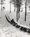
| Date: | 1956 |
|---|---|
| Description: | An adult and a child riding a toboggan down the slide at Iverson Park. |

| Date: | 1891 |
|---|---|
| Description: | The index page of a Sanborn Map of Stevens Point. |

| Date: | 1891 |
|---|---|
| Description: | Page 13 of a Sanborn map of Stevens Point. |
If you didn't find the material you searched for, our Library Reference Staff can help.
Call our reference desk at 608-264-6535 or email us at: