 Filter: Categories of Wisconsin Historical Images
Filter: Subject of Land
Filter: County of Milwaukee
Filter: Categories of Wisconsin Historical Images
Filter: Subject of Land
Filter: County of Milwaukee

| Date: | 1964 |
|---|---|
| Description: | This map shows various zoning sections and includes labeled streets, parks, and cemeteries. The upper left corner contains a legend of land use. |
| Date: | 02 25 1965 |
|---|---|
| Description: | This blue line print map shows annexed land with ordinance numbers and dates. |

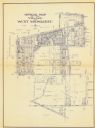
| Date: | 1965 |
|---|---|
| Description: | This map shows 32 zoning districts, house numbering system, parks, cemeteries, and Milwaukee County institutional buildings. |
| Date: | 1954 |
|---|---|
| Description: | This blue line print shows lot and block numbers and dimensions, additions, railroads, streets, and parks. |
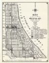
| Date: | 1965 |
|---|---|
| Description: | This map shows 8 zoning districts, as well as house number system, schools, parks, churches, and points of interest. Lake Michigan is labeled and the lower... |

| Date: | 1910 |
|---|---|
| Description: | This ink on paper blue line print base map consists of eight separate pieces and shows city limits, The Milwaukee Electric Railroad & Light Company lines, ... |

| Date: | 1924 |
|---|---|
| Description: | This map shows streets, selected buildings, railroads, railway yards, schools, parks, schools, cemeteries, bays, the Milwaukee River, and Lake Michigan. De... |

| Date: | 1926 |
|---|---|
| Description: | This map shows streets, railroads, parks, and cemeteries. The top right includes an advertisement for Bartles-Maguire Oil Co. Wards are colored in red, yel... |

| Date: | 1927 |
|---|---|
| Description: | This map shows street car lines, bus routes, railroads, proposed city boundary lines, wards, public schools, blocks & house numbers, Lake Michigan, one mil... |

| Date: | 1927 |
|---|---|
| Description: | This map shows highways, roads, a proposed annexation, street car lines, bus routes, local motor bus lines, a new high speed interurban, railroads, a propo... |

| Date: | 1930 |
|---|---|
| Description: | This map shows streets, railways, bus lines, railroads, roads, parks, cemeteries, Lake Michigan, and a proposed harbor. Also included is a legend and on th... |
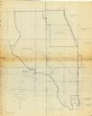
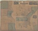
| Date: | 1855 |
|---|---|
| Description: | This map shows plat of town, local streets, numbered blocks and lots, proposed city park, Murray’s addition, and part of Lake Michigan. Also includes a tab... |

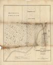
| Date: | 1854 |
|---|---|
| Description: | This map shows bay and harbor soundings, the Milwaukee River, and select buildings. Depths are shown by soundings and relief is shown by hachures. The top ... |
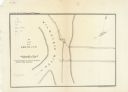
| Date: | 1854 |
|---|---|
| Description: | This map is oriented with north slightly to the right and the Milwaukee River is labeled. The top margin reads: "Senate Ex. Doc. No. 1. 1st Session, 33rd C... |
| Date: | 1858 |
|---|---|
| Description: | This map made up of six panels shows communities, rivers, and Lake Michigan. The map includes several inset maps showing Milwaukee, Humboldt, Franklin, Oak... |
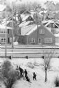
| Date: | 11 30 1976 |
|---|---|
| Description: | Elevated view of children sliding on the snow near the Bay Street overpass to Jones Island. The children are walking up the hill. In the background is a st... |

| Date: | 1948 |
|---|---|
| Description: | This map shows the land parcels, streets, and parks near the harbor. It includes a wind chart and 7 cross sections of borings/probings and docks. It also i... |
| Date: | 1940 |
|---|---|
| Description: | This map is pen and ink on paper and is map 6 in a series of 12. The map shows streets, and the Milwaukee River. |
| Date: | 1962 |
|---|---|
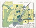
| Description: | This map shows zoning, community facilities, roads, rivers and thoroughfares. The lower right corner includes a key titled "General Plan". |
| Date: | 1882 |
|---|---|
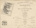
| Description: | Card menu for the Wisconsin Authors' Club Banquet at Klosterheim. On the top left is a framed landscape of trees overlooking a body of water. |
If you didn't find the material you searched for, our Library Reference Staff can help.
Call our reference desk at 608-264-6535 or email us at: