 Filter: Categories of Wisconsin Historical Images
Filter: Subject of Land
Filter: County of Milwaukee
Filter: Categories of Wisconsin Historical Images
Filter: Subject of Land
Filter: County of Milwaukee

| Date: | 1902 |
|---|---|
| Description: | Two-wheeled show cart with pair of white show horses in tandem hitch, being driven by one person, probably along Lake Michigan. |

| Date: | 1964 |
|---|---|
| Description: | Docks at Jones Island with a lone swan swimming. Many large ships and city buildings can be seen in the background. |

| Date: | 1850 |
|---|---|
| Description: | This map of the Town of Lake is ink and pencil on paper and shows lots and acreages, reserved land, and public squares. The bottom of the map includes a ke... |

| Date: | 1881 |
|---|---|
| Description: | Bird's-eye view of Milwaukee from the south lakeshore. |

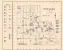
| Date: | 1938 |
|---|---|
| Description: | This map shows buildings, lots, parks, schools, pumping stations, sites reserved for churches, and water towers. |
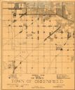
| Date: | 1930 |
|---|---|
| Description: | This map shows 6 types of zones, as well as cemeteries and streets and includes portions of Greenfield, West Allis, West Milwaukee, and the city of Milwauk... |

| Date: | 1961 |
|---|---|
| Description: | Evacuation route out of Milwaukee. View from the side of the road looking downhill towards the rear of a Wisconsin State Patrol cruiser parked on the right... |

| Date: | 1964 |
|---|---|
| Description: | This map is a hand-colored blue line print and shows 4 residence zones, 2 business zones, 1 light manufacturing zones, schools, and parks. The zones are ou... |
| Date: | 1965 |
|---|---|
| Description: | This map shows Milwaukee County Parkway lands, streets, streets not yet constructed, public facilities, schools, churches, and manufacturers. The map inclu... |
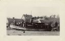
| Date: | 1931 |
|---|---|
| Description: | The Frank Braeger is moored on the shore of Jones Island with steam issuing from the pipe, with the crew posing on the boat. In the background a man... |

| Date: | 1931 |
|---|---|
| Description: | Fishermen from the Frank Braeger fishing tugboat are standing for a group portrait in front of their fishing nets on Jones Island. |

| Date: | 1931 |
|---|---|
| Description: | Two smiling fishermen stand before their fishing nets on Jones Island. There are floats attached to one net and a barrel with a jacket on top of it. |
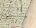
| Date: | 1893 |
|---|---|
| Description: | Detail of a Milwaukee County map that shows sections 20 and 21 at Range 22 East, Township 8 North. |

| Date: | 1951 |
|---|---|
| Description: | This map is a survey of Lake Michigan and the section of Milwaukee that borders the lake. Map of land includes major streets, and landmarks near water. Rel... |

| Date: | 1840 |
|---|---|
| Description: | This manuscript map is ink, pencil, and watercolor on paper and shows landownership. An approximate date can be established by the names written on the pla... |

| Date: | 1855 |
|---|---|
| Description: | This map shows lot and block numbers, buildings, some landownership, roads, railroads, cemeteries, the Milwaukee River, and Lake Michigan. The map includes... |

| Date: | 1856 |
|---|---|
| Description: | This map shows lot and block numbers, wards, roads, railroads, and some landowner names. Lake Michigan and the Milwaukee River are labeled. Includes an ins... |

| Date: | 1857 |
|---|---|
| Description: | This map shows lot and block numbers, wards, roads, railroads, some landowners’ names, and selected buildings. The map includes an inset map of Glidden & L... |

| Date: | 1857 |
|---|---|
| Description: | This map shows lot and block numbers, wards, roads, railroads, some landowners’ names, and selected buildings. Lake Michigan, the Milwaukee River, and Glid... |

| Date: | 1902 |
|---|---|
| Description: | This map is a chart of Milwaukee Harbor that displays local streets, bridges, roads, railroads, public buildings, businesses, factories, dry docks, parks, ... |
If you didn't find the material you searched for, our Library Reference Staff can help.
Call our reference desk at 608-264-6535 or email us at: