 Filter: Categories of Wisconsin Historical Images
Filter: Subject of Land
Filter: County of Milwaukee
Filter: Categories of Wisconsin Historical Images
Filter: Subject of Land
Filter: County of Milwaukee

| Date: | 1965 |
|---|---|
| Description: | A map of Milwaukee County showing the county supervisor districts and the city wards. The map also includes the names of those on the on the board of elect... |

| Date: | 1830 |
|---|---|
| Description: | An ink on paper, hand-drawn map of the town of Milwaukee, showing the divisions and landownership within the town by private individuals as well as those l... |

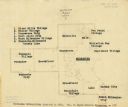
| Date: | 1835 |
|---|---|
| Description: | This map is pen-and-ink on paper. The map shows landowners in "Milwalky" or present day Milwaukee. Includes "list of property offered to Mr. Walker". The m... |

| Date: | 1836 |
|---|---|
| Description: | Pencil on tracing paper. Rough sketch of Milwaukee. Left top corner reads: "From Map of northern part of Illinois and the surveyed part of Wisconsin Territ... |

| Date: | 1836 |
|---|---|
| Description: | This map shows settlers houses and businesses, trails, and swamps. The relief is shown by hachures. The map includes illustrations of historical buildings ... |

| Date: | 1890 |
|---|---|
| Description: | Map of Milwaukee as remembered by "Dr Enoch Chase, U.B. Smith & Others." Represented are major roads, lowlands, trails, homesteads, and lots. Map depicts t... |

| Date: | 06 1837 |
|---|---|
| Description: | Pen-and-ink on paper. Shows riverside property west of the Milwaukee River. Inscribed by several early Milwaukee settlers, including Henry W. Cleveland, Cy... |

| Date: | 1854 |
|---|---|
| Description: | Reproduction printed on glossy, cloth-backed paper. Right side includes "References," or points of interest that correspond to numbers on the map. Running ... |
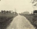
| Date: | 1925 |
|---|---|
| Description: | View down dirt road running through homes and trees in a neighborhood. A man stands in the road. Text at foot of photograph reads, "Toelle Ave. 138+12 Look... |
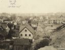
| Date: | 10 30 1925 |
|---|---|
| Description: | Elevated view of alley between houses in a neighborhood from railroad embankment. An elevated bridge is just visible in the far background. Text at foot of... |

| Date: | 1877 |
|---|---|
| Description: | Two maps on one page, removed from an atlas. The first map shows Wisconsin and the upper peninsula of Michigan counties and townships while the second map ... |
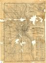
| Date: | 1886 |
|---|---|
| Description: | Two maps on one page. The first page is a map of Milwaukee County with insets "Plan of Pewaukee, Waukesha Co.," "Plan of Oconomowoc, Waukesha Co.," "Plan o... |
| Date: | 1890 |
|---|---|
| Description: | Map of Merrill Estate property for sale and sold. Map reads: "Merrill Estate property (colored) lots marked X are sold for terms & prices inquire of S.H. C... |

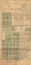
| Date: | 1896 |
|---|---|
| Description: | Map highlighting parks and other points of interest in Milwaukee. |

| Date: | 1931 |
|---|---|
| Description: | This map is an advertisement for Milwaukee street cars and motor buses and reads: "Ride the street car or motor bus. Economical, safe, dependable." Include... |

| Date: | 1934 |
|---|---|
| Description: | Map showing the ward boundaries of Milwaukee. Each ward is numbered and boundary streets are labelled. The bottom right corner reads: "CITY ENGINEER'S DEPT... |

| Date: | 1950 |
|---|---|
| Description: | This map is accompanied by booklet: "Know Milwaukee Map and Street Guide". The map is a detailed map of Milwaukee and the surrounding suburbs. Streets and ... |
| Date: | 12 23 1949 |
|---|---|
| Description: | Typed and printed ink on paper. Map lists and shows suburbs in 1940. Map reads: "Milwaukee Metropolitan district in 1940. Pub. in Bayrd Still’s Milwaukee, ... |

| Date: | 1836 |
|---|---|
| Description: | This map is pen-and-ink on paper and shows marshlands, rivers, creeks, a quarry, and a few roads. |

| Date: | 1848 |
|---|---|
| Description: | Pen-and-ink on paper. The title of the map is inscribed on the back. The map shows buildings, roads, marshes, wild rice, piles and docks, deep water, and o... |
If you didn't find the material you searched for, our Library Reference Staff can help.
Call our reference desk at 608-264-6535 or email us at: