Filter: Categories of Wisconsin Historical Images
Filter: Subject of Land
Filter: County of Manitowoc
Filter: Categories of Wisconsin Historical Images
Filter: Subject of Land
Filter: County of Manitowoc

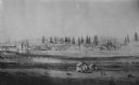
| Date: | 1870 |
|---|---|
| Description: | Bird's-eye view of the city of Manitowoc with a population of 5,168 inhabitants as it appears in 1870, the year the village was granted a city charter by t... |

| Date: | 1879 |
|---|---|
| Description: | Bird's-eye map of Two Rivers. |
| Date: | 05 05 1897 |
|---|---|
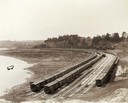
| Description: | Elevated view of Wisconsin Central freight cars in a rural storage yard near Manitowoc. |
| Date: | 1900 |
|---|---|
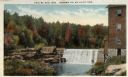
| Description: | View of a dam surrounded by autumnal trees. An industrial building is on the right. The scene is Shoto Falls, in the Town of Shoto, near Two Rivers. Captio... |
| Date: | 1860 |
|---|---|
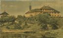
| Description: | Elevated view of the Roman Catholic community of St. Nazianz. |
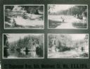
| Date: | 1914 |
|---|---|
| Description: | Various views of places in Oslo. Text at bottom reads: "Stephenson Bros., Oslo, Manitowoc Co., Wis., U.S.A., 1914." |
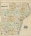
| Date: | 1878 |
|---|---|
| Description: | Outline map of Manitowoc County. Includes engraving of Wisconsin State Seal at bottom right. |

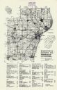
| Date: | 1947 |
|---|---|
| Description: | A map of Manitowoc County that shows the location and dates of seven pig fairs in the county; it also lists monthly pig and cattle sales in the surrounding... |
| Date: | 1976 |
|---|---|
| Description: | A map of Manitowoc County, Wisconsin, showing the location of 94 cemeteries in the county. The map also shows major roads that travel to the city of Manito... |
| Date: | 1955 |
|---|---|
| Description: | These 24 plat maps of the Town of Newton, Manitowoc County, Wisconsin, show soil type; mortgages in force as of January 1, 1932; land warrants holders; mor... |

| Date: | 1800 |
|---|---|
| Description: | This 19th-century manuscript map of the Town of Newton, Manitowoc County, Wisconsin, shows sections, lakes and streams, the trail from Chicago to Green Bay... |

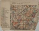
| Date: | 1872 |
|---|---|
| Description: | Shows townships and sections, landownership and acreages, roads, railroads, churches, schools, and cemeteries. Includes business directories of Manitowoc ... |

| Date: | 1960 |
|---|---|
| Description: | This map is a cadastral map and shows block and lot numbers and dimensions, additions, streets, railroad, and Kiel Municipal Cemetery. The bottom right mar... |

| Date: | |
|---|---|
| Description: | Back of card reads: "One of the Everglade appearing sloughs running along for miles parallel with the Lake Michigan shore — This view seen from the park ... |
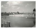
| Date: | 07 02 1960 |
|---|---|
| Description: | View across water towards the Manitowoc Shipbuilding floating drydock. Pilings and grass are in the foreground. On the far shoreline are buildings on a hil... |

| Date: | 01 08 1958 |
|---|---|
| Description: | Elevated view over icy water towards ships in the shipyard on the left, and the cement company in the background. Cranes and industrial buildings are in th... |

| Date: | |
|---|---|
| Description: | This plat map shows numbered blocks and lots, wards, local streets, railroads, cemeteries, buildings, land ownership by name, and parts of Manitowoc River ... |

| Date: | 1903 |
|---|---|
| Description: | This map shows lakes, roads, railroads, townships, and land ownership by name. Counties are colored red, blue, or yellow. Lake Michigan is labeled. Also in... |
If you didn't find the material you searched for, our Library Reference Staff can help.
Call our reference desk at 608-264-6535 or email us at: