Filter: Categories of Wisconsin Historical Images
Filter: Subject of Land
Filter: County of Lafayette
Filter: Categories of Wisconsin Historical Images
Filter: Subject of Land
Filter: County of Lafayette

| Date: | 1833 |
|---|---|
| Description: | Township/section map showing Rodolf land and nearby neighbors. |

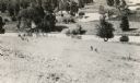
| Date: | 1834 |
|---|---|
| Description: | Peck-a-ton-oka (Pecatonica River) with Rodolf farm in the background. |

| Date: | 1896 |
|---|---|
| Description: | Bird's-eye map of Darlington. Area bordered by Washington and North Streets, upper left hand corner, the fairgrounds, upper right corner, River Street, bot... |
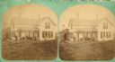
| Date: | 1876 |
|---|---|
| Description: | Two men, two women are posing in front of a frame house that has a chair, sofa, table and a small white statue on its front porch. There are three doors an... |
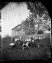
| Date: | 1873 |
|---|---|
| Description: | The home of the Reverend Carl Christian Aas (1843-1898), with the family posing around a table in front of a fence in the foreground. There is a rocking ho... |
| Date: | 1900 |
|---|---|
| Description: | Elevated view of wagon bridge in Darlington, with a river on the right, a cow in a field, and a building on the left. |
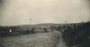
| Date: | 1935 |
|---|---|
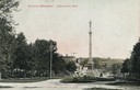
| Description: | View toward bridge and hill. The bridge has lampposts. Buildings are on a hill in the background. Caption reads: "Bridge and Hill, Darlington, Wis." |
| Date: | 1905 |
|---|---|
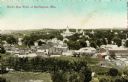
| Description: | Caption reads: "Bird's Eye View of Darlington, Wis." |
| Date: | 1905 |
|---|---|
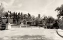
| Description: | View down street towards Soldiers' Monument. Caption reads: "Soldiers' Monument, Darlington, Wis." |
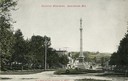
| Date: | 1907 |
|---|---|
| Description: | View down road looking towards Soldiers' Monument and town beyond. Caption reads: "Soldiers' Monument, Darlington, Wis." |
| Date: | 1935 |
|---|---|
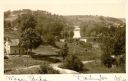
| Description: | Elevated view of Darlington, with the bridge over the river in the foreground, and the town beyond. Caption reads: "View from the Hill, Darlington, Wis." |

| Date: | 1910 |
|---|---|
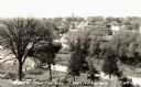
| Description: | Elevated view of the Pecatonica River, which is curving from left to right, making two hairpin turns among fields and trees. Hills are in the distance. |
| Date: | |
|---|---|
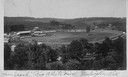
| Description: | Elevated view from hill of the racetrack at the "Big White Fair". |

| Date: | 1957 |
|---|---|
| Description: | Aerial view of Yellowstone Lake and surrounding countryside. |
| Date: | 1936 |
|---|---|
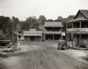
| Description: | Slightly elevated view of storefronts on Main Street. Sign on building reads: "Pabst Blue Ribbon Beer." Child standing at pump (water pump?) Two cars parke... |

| Date: | 1874 |
|---|---|
| Description: | Map of New Diggings — inset map in bottom right corner of "Benton & New Diggings" map, on page 11 of "Atlas of Lafayette County Wisconsin," a collect... |

| Date: | 04 30 1949 |
|---|---|
| Description: | Aerial photograph of Blanchardville. |

| Date: | 1936 |
|---|---|
| Description: | View from road of lead and zinc mines and surrounding buildings. |
If you didn't find the material you searched for, our Library Reference Staff can help.
Call our reference desk at 608-264-6535 or email us at: