 Filter: Categories of Wisconsin Historical Images
Filter: Subject of Land
Filter: County of Grant
Filter: Categories of Wisconsin Historical Images
Filter: Subject of Land
Filter: County of Grant

| Date: | 1920 |
|---|---|
| Description: | A map of the Nelson-Dewey State Park at the confluence of the Mississippi and Wisconsin rivers, showing the topographical features of the area, as well as ... |

| Date: | 1920 |
|---|---|
| Description: | This 1920 map actually depicts present-day Wyalusing State Park at the confluence of the Mississippi and Wisconsin rivers in the Town of Wyalusing, Grant C... |

| Date: | 1857 |
|---|---|
| Description: | Relief shown by hachures. "Lith. of Ed. Mendel, Chicago." Shows townships and sections, rivers, roads, railroads, houses, flour mills, saw mills, furnaces... |

| Date: | 1928 |
|---|---|
| Description: | Shows different types of roads, railroads, schools, churches, farmsteads, cheese factories, mine shafts, old surface workings, streams, old sulphur pits, a... |

| Date: | 1972 |
|---|---|
| Description: | Ink on tracing paper. This map shows rivers, Prairie du Chien, site of Fort Crawford, Excelsior, Fort Andrew, Boscobel, Blue River, Orion, Muscoda, Castle ... |

| Date: | 1848 |
|---|---|
| Description: | Pen-and-ink on paper. Includes certifications signed by "Geo R. Bluntz, District Survey of Grant Co. W.T." and Ben C. Eastman. |

| Date: | |
|---|---|
| Description: | View over town, including hotel and church, towards the Mississippi River. The far shoreline and bluffs are in the distance. |

| Date: | |
|---|---|
| Description: | Elevated view of Cassville, including the town hall and St. Peter's Church. |
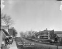
| Date: | 1913 |
|---|---|
| Description: | View down sidewalk towards a sign that says "... and Lodging England's" for a boarding house is on the extreme left. Next to the sign is a building with a ... |

| Date: | |
|---|---|
| Description: | View towards depot of a train pulling up to the platform. A group of men are on the far left behind the depot. Metal parts, firewood and wooden crates are ... |

| Date: | |
|---|---|
| Description: | Ruins of an old furnace. There is a pile of stones and the remains of a wheel. In the background is a hill with trees. |

| Date: | |
|---|---|
| Description: | A view of a cemetery with stone grave markers among pine trees. A barbed wire fence surrounds the perimeter. Wooden steps go over the fence next to the gat... |
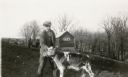
| Date: | 1931 |
|---|---|
| Description: | Claire Alexander posing with a young calf in a pasture near a wooded ravine at his father's farm. There is a manure spreader and shed in the background. |

| Date: | 1921 |
|---|---|
| Description: | A passenger train stopped at the depot. Three men are standing on the left, one of them pushing a cart. A row of milk cans is along the side of the depot b... |

| Date: | |
|---|---|
| Description: | View down platform and two sets of railroad tracks towards depot. One man stands on the platform in the foreground. Two people are further down the tracks ... |

| Date: | |
|---|---|
| Description: | Elevated view from bluff overlooking the railroad tracks and yard along the Mississippi River. A group of men are gathered on the track near stacks of lumb... |

| Date: | |
|---|---|
| Description: | Three-quarter view of the Congregational Church, a wood structure with a belfry and steeple. There are arched windows and a flight of stairs to the entranc... |

| Date: | 1929 |
|---|---|
| Description: | View from entrance of a cave looking out to the Mississippi River, a railroad bridge, all surrounded by a forest. There is a small island in the river. |

| Date: | 1929 |
|---|---|
| Description: | Elevated view from Signal Point of the Mississippi River, railroad and surrounding forest and wetlands. |

| Date: | 1929 |
|---|---|
| Description: | A rock formation called "Black Hawk Monument" in Nelson Dewey State Park -- now Wyalusing State Park. |
If you didn't find the material you searched for, our Library Reference Staff can help.
Call our reference desk at 608-264-6535 or email us at: