 Filter: Categories of Wisconsin Historical Images
Filter: Subject of Land
Filter: County of Door
Filter: Categories of Wisconsin Historical Images
Filter: Subject of Land
Filter: County of Door

| Date: | 1940 |
|---|---|
| Description: | This tourist map of Door County, Wisconsin, lists the points of interest and tourist hotels, cabins and cottages in the area. Ferry schedules to Washington... |

| Date: | 1930 |
|---|---|
| Description: | "Issued by Door County Chamber of Commerce." Shows federal system highways, state highways, county trunk highways, country roads, and parks. Includes direc... |
| Date: | 1920 |
|---|---|
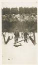
| Description: | Two unidentified young men pose in the snow with their firearms behind seven dead rabbits displayed on a barbed wire fence; there are three dogs on the oth... |
| Date: | |
|---|---|
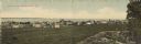
| Description: | Colorized panoramic view of businesses and dwellings along the shore of Lake Michigan. A rock formation and a tree in the lower right. Caption reads: "Gree... |
| Date: | 1910 |
|---|---|
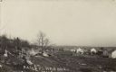
| Description: | Photographic postcard view across rocky field of dwellings and other buildings along Lake Michigan. Along the left is a rocky ledge. The shoreline of the h... |

| Date: | 1934 |
|---|---|
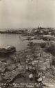
| Description: | Photographic postcard view along the rocky shoreline of Lake Michigan towards a long pier that jutts out behind the rocky point. Caption reads: "Along the ... |
| Date: | |
|---|---|
| Description: | Photographic postcard view along the rocky shoreline of Lake Michigan, including tall grass and shrubs. Caption reads: "A Bit of Rocky Shore - Gordon Lodge... |
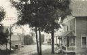
| Date: | 1909 |
|---|---|
| Description: | View of Main Street, Sister Bay, looking downhill. Caption reads: Main Street, Sister Bay, Wis." |

| Date: | 1924 |
|---|---|
| Description: | Plat map showing a portion of Liberty Grove, T32-33N R29E. The land is bordered on the south by Rowley's Bay, on the east by Lake Michigan and Europe Bay, ... |

| Date: | 1941 |
|---|---|
| Description: | Elevated view of Sturgeon Bay in 1900. Sturgeon Bay Bridge spans the bay and several boats are on the water. A lighthouse sits on a small island in the bay... |
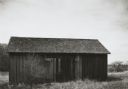
| Date: | 1963 |
|---|---|
| Description: | View of a barn with trees and rolling land in the background. |
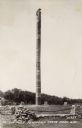
| Date: | |
|---|---|
| Description: | The totem pole has a carved wooden bear clinging to the top. The totem pole was erected in 1927 in honor of the aboriginal inhabitants of Wisconsin. Potawa... |
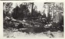
| Date: | 1941 |
|---|---|
| Description: | This photograph of downed trees and branches is annotated, possibly by C.L. Harrington: "A fire hazard at this date Feb 28 '41. I have salvaged all or ab... |

| Date: | |
|---|---|
| Description: | Aerial view of Potawatomi State Park, with the Sturgeon Bay shoreline in the background. |
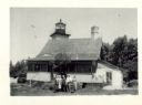
| Date: | 07 04 1947 |
|---|---|
| Description: | Group of people standing in the yard in front of the lighthouse. The verso has this annotation: "'Eagle Light' Lighthouse, Peninsula Park, Fish Creek, Wi... |
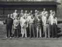
| Date: | 05 19 1957 |
|---|---|
| Description: | Group portrait of men standing on a lawn in front of a building. C.L. (Neal) Harrington is in the third row on the right end. The meeting was held in Penin... |

| Date: | 1920 |
|---|---|
| Description: | View from beach across Spike Horn Bay towards Cana Island and the Cana Island Light. |

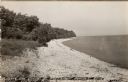
| Date: | 1966 |
|---|---|
| Description: | A colored map depiction of Door County, Wisconsin, with pictorial highlights, titled: "Door County — Wisconsin's Air Conditioned Peninsula Playground." |
| Date: | 1940 |
|---|---|
| Description: | Black and white photographic postcard view along the shoreline of Lake Michigan at Northport. |

| Date: | 1960 |
|---|---|
| Description: | View across water towards a man, woman, and two children standing on the rock ledge at Cave Point. Lake Michigan is on the right. |
If you didn't find the material you searched for, our Library Reference Staff can help.
Call our reference desk at 608-264-6535 or email us at: