 Filter: Categories of Wisconsin Historical Images
Filter: Subject of Land
Filter: County of Door
Filter: Categories of Wisconsin Historical Images
Filter: Subject of Land
Filter: County of Door

| Date: | 1915 |
|---|---|
| Description: | Elevated view, looking north, from the Hotz family compound near the bluff entrance to Fish Creek. Evergreens and bare birch trees stand in the foreground,... |
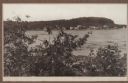
| Date: | 1915 |
|---|---|
| Description: | View looking north over Fish Creek Bay, with Hen Island and Peninsula State Park in the background. There is snow on the ground, and evergreens and bare bi... |
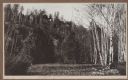
| Date: | 1914 |
|---|---|
| Description: | View from below a bluff, through evergreens and birch trees, looking up at the Hotz Fish Creek compound. The stone garage and tower are on the left. |
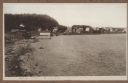
| Date: | 1912 |
|---|---|
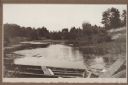
| Description: | View looking west from the Hotz property on Fish Creek Beach. The Thorp bathhouse is on the left, with the Welcker bathhouses beyond. There are houses an... |
| Date: | 1913 |
|---|---|
| Description: | View from the base of the bluff looking up at the Hotz compound. A flag blows in the breeze above birch and evergreen trees. A woman is standing on the por... |
| Date: | 1915 |
|---|---|
| Description: | View of Fish Creek from Weborg's Point in Peninsula State Park. The Fish Creek dock with barnlike warehouse is in center right. Behind the dock is the two-... |

| Date: | 1915 |
|---|---|
| Description: | An unidentified child sits on the rocky shore at Weborg Point. Big Strawberry Island is seen center right, with Chambers Island on the horizon to the left. |

| Date: | 1915 |
|---|---|
| Description: | Elevated view over a heavily wooded area to Fish Creek Harbor and Hen Island, with Peninsula State Park in the background. |
| Date: | 1915 |
|---|---|
| Description: | View from shoreline over water towards a three-masted sailing vessel docked at Baileys Harbor pier. Houses and commercial buildings line the shore. |

| Date: | 1915 |
|---|---|
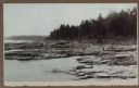
| Description: | Birch and evergreen trees line the rocky shore of Toft Point, with Cana Island and its lighthouse in the background. |
| Date: | 1915 |
|---|---|
| Description: | Mr. Paepcke, identified as an accountant, in white suit, poses with two unidentified men on large rocks on the shore of Europe Bay. Plum Island and Detroit... |
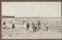
| Date: | 1915 |
|---|---|
| Description: | A group of children and adults enjoy a sunny day at the beach. Those identified include Mrs. Ferdinand (Clothilde Schmidt) Hotz, on left with hat and light... |
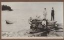
| Date: | 1915 |
|---|---|
| Description: | A wooden boat forms the foreground of a view of a stream, probably Shivering Sands Creek, and wetlands, with a sand dune on the right. |

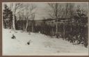
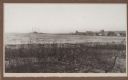
| Date: | 1915 |
|---|---|
| Description: | A view, from above Juddville, looking north across a rocky meadow toward wooded bluffs near Fish Creek. A fence crosses the meadow and there is a saltbox-s... |
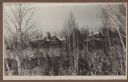
| Date: | 1915 |
|---|---|
| Description: | A dense stand of evergreens and birch trees line the rocky shore near Dr. Gordon's cottage on North Bay. |

| Date: | 1915 |
|---|---|
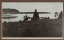
| Description: | View across rocky shoreline of Dr. Gordon standing in front of his cottage on the rocky North Bay shore. The cottage is partially obscured in a dense stand... |
| Date: | 1915 |
|---|---|
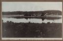
| Description: | Hen Island is reflected in the water of Fish Creek Bay in this view from Nelson Point in Peninsula State Park. The homes and businesses of Fish Creek are i... |
| Date: | 1915 |
|---|---|
| Description: | View down hill towards a man fishing from the pier at Nelson Point in Peninsula State Park. Fish Creek is seen across the bay. Dr. Welcker's Casino is the ... |

| Date: | 1938 |
|---|---|
| Description: | This tourist map of Door County, Wisconsin, lists the points of interest and resorts in the area. An inset location map is included. |

| Date: | 1943 |
|---|---|
| Description: | This 1943 map of Door County, Wisconsin, identifies the post offices and rural routes in the county. Highways and roads, cities and villages, and rural res... |
If you didn't find the material you searched for, our Library Reference Staff can help.
Call our reference desk at 608-264-6535 or email us at: