 Filter: Categories of Wisconsin Historical Images
Filter: Subject of Land
Filter: County of Door
Filter: Subject of water
Filter: Categories of Wisconsin Historical Images
Filter: Subject of Land
Filter: County of Door
Filter: Subject of water
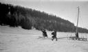
| Date: | 1920 |
|---|---|
| Description: | Three men work with an iceboat just offshore near Cottage Row Road. The sail and boom lie on the ice. There are boathouses and three windmills along the ... |
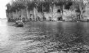
| Date: | 1912 |
|---|---|
| Description: | A launch with men standing on the deck passes close to rocky bluffs as seagulls fly overhead. |
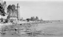
| Date: | 1915 |
|---|---|
| Description: | View from shoreline over water towards the Coast Guard Station and houses at Baileys Harbor. The long pier extending from the station's boathouse is easily... |
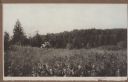
| Date: | 1925 |
|---|---|
| Description: | Two young men pick berries in a field on a hill near Juddville. Chambers Island is seen on the horizon of the Green Bay. |
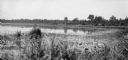
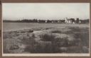
| Date: | 1925 |
|---|---|
| Description: | View of a marshy shoreline with grasses in the foreground. The far shoreline is lined with trees. |
| Date: | 1912 |
|---|---|
| Description: | The Cana Island lighthouse and keeper's house with the rocky shore in the foreground. |
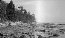
| Date: | 1912 |
|---|---|
| Description: | Cana Island lighthouse is seen in the far distance across the stony shoreline along Lake Michigan. |
| Date: | 1919 |
|---|---|
| Description: | A child and an adult follow a small herd of cattle walking up the dirt road, now Highway 42, north out of Sister Bay. The bell tower of Zion Lutheran Churc... |

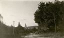
| Date: | 1920 |
|---|---|
| Description: | A car is parked along a narrow dirt road with a house, barn and outbuildings in the background. A split-rail fence lines the left side of the road. There i... |
| Date: | 1915 |
|---|---|
| Description: | Ferdinand Hotz poses with his wife Clothilde (with glasses), son Ferdinand Leonard (Fedy) and one of his daughters on Champagne Rock on Cottage Row. |
| Date: | 1920 |
|---|---|
| Description: | View along shoreline towards a rustic foot bridge which crosses the mouth of Fish Creek, which separates the village of Fish Creek from Peninsula State Par... |
| Date: | 1924 |
|---|---|
| Description: | Elevated view of the photographer's son, Ferdinand Leonard (Fedy) sitting on the bluff overlooking Fish Creek Harbor. The old warehouses are seen on the pi... |

| Date: | 1916 |
|---|---|
| Description: | This Wisconsin Conservation Commission map from 1916 shows Peninsula State Park in the Town of Gibraltar, Door County, Wisconsin. Depicted are open and pla... |

| Date: | 1916 |
|---|---|
| Description: | This version of a 1916 Wisconsin Conservation Commission map shows Peninsula State Park in the Town of Gibraltar, Door County, Wisconsin. Depicted are open... |

| Date: | 1930 |
|---|---|
| Description: | Aerial view, looking northeast, across Mud Lake with North Bay in the background, showing cultivated fields and wooded land. |

| Date: | 1930 |
|---|---|
| Description: | Aerial view looking north across the wooded peninsula separating Europe Bay (top) from Newport Bay. This area is now part of Newport State Park. |

| Date: | 1930 |
|---|---|
| Description: | Aerial view of the northern tip of the Door Peninsula, looking north. Europe Lake is in the center, with Europe Bay to the right. Plum Island and Washingto... |

| Date: | 1930 |
|---|---|
| Description: | Aerial view looking northeast, with Rowley's Bay in the foreground. Europe Lake is to the left, with Europe Bay and Newport Bay separated by a narrow peni... |

| Date: | 1930 |
|---|---|
| Description: | Aerial view over northern Door County, looking northeast across Europe Lake and Europe Bay toward Plum and Washington Islands. Farm fields and orchards con... |

| Date: | 1930 |
|---|---|
| Description: | Aerial view from over Moonlight Bay, looking east across Bues Point to Spike Horn Bay and Cana Island. The Cana Island Lighthouse is seen as a ship passes ... |
If you didn't find the material you searched for, our Library Reference Staff can help.
Call our reference desk at 608-264-6535 or email us at: