 Filter: Categories of Wisconsin Historical Images
Filter: Subject of Land
Filter: County of Door
Filter: Subject of michigan, lake
Filter: Categories of Wisconsin Historical Images
Filter: Subject of Land
Filter: County of Door
Filter: Subject of michigan, lake
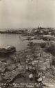
| Date: | 1915 |
|---|---|
| Description: | View from shoreline over water towards a three-masted sailing vessel docked at Baileys Harbor pier. Houses and commercial buildings line the shore. |

| Date: | 1915 |
|---|---|
| Description: | Birch and evergreen trees line the rocky shore of Toft Point, with Cana Island and its lighthouse in the background. |
| Date: | 1915 |
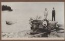
|---|---|
| Description: | Mr. Paepcke, identified as an accountant, in white suit, poses with two unidentified men on large rocks on the shore of Europe Bay. Plum Island and Detroit... |
| Date: | 1915 |
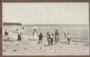
|---|---|
| Description: | A group of children and adults enjoy a sunny day at the beach. Those identified include Mrs. Ferdinand (Clothilde Schmidt) Hotz, on left with hat and light... |

| Date: | 1915 |
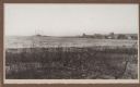
|---|---|
| Description: | A view, from above Juddville, looking north across a rocky meadow toward wooded bluffs near Fish Creek. A fence crosses the meadow and there is a saltbox-s... |
| Date: | 1915 |
|---|---|
| Description: | A dense stand of evergreens and birch trees line the rocky shore near Dr. Gordon's cottage on North Bay. |

| Date: | 1915 |
|---|---|
| Description: | View across rocky shoreline of Dr. Gordon standing in front of his cottage on the rocky North Bay shore. The cottage is partially obscured in a dense stand... |
| Date: | 1915 |
|---|---|
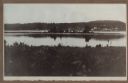
| Description: | Hen Island is reflected in the water of Fish Creek Bay in this view from Nelson Point in Peninsula State Park. The homes and businesses of Fish Creek are i... |
| Date: | 1915 |
|---|---|
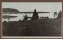
| Description: | View down hill towards a man fishing from the pier at Nelson Point in Peninsula State Park. Fish Creek is seen across the bay. Dr. Welcker's Casino is the ... |

| Date: | 1943 |
|---|---|
| Description: | This 1943 map of Door County, Wisconsin, identifies the post offices and rural routes in the county. Highways and roads, cities and villages, and rural res... |
| Date: | |
|---|---|
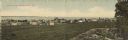
| Description: | Colorized panoramic view of businesses and dwellings along the shore of Lake Michigan. A rock formation and a tree in the lower right. Caption reads: "Gree... |
| Date: | 1910 |
|---|---|
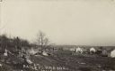
| Description: | Photographic postcard view across rocky field of dwellings and other buildings along Lake Michigan. Along the left is a rocky ledge. The shoreline of the h... |

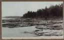
| Date: | 1934 |
|---|---|
| Description: | Photographic postcard view along the rocky shoreline of Lake Michigan towards a long pier that jutts out behind the rocky point. Caption reads: "Along the ... |
| Date: | |
|---|---|
| Description: | Photographic postcard view along the rocky shoreline of Lake Michigan, including tall grass and shrubs. Caption reads: "A Bit of Rocky Shore - Gordon Lodge... |

| Date: | 1924 |
|---|---|
| Description: | Plat map showing a portion of Liberty Grove, T32-33N R29E. The land is bordered on the south by Rowley's Bay, on the east by Lake Michigan and Europe Bay, ... |

| Date: | |
|---|---|
| Description: | Aerial view of Potawatomi State Park, with the Sturgeon Bay shoreline in the background. |

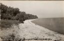
| Date: | 1920 |
|---|---|
| Description: | View from beach across Spike Horn Bay towards Cana Island and the Cana Island Light. |

| Date: | 1966 |
|---|---|
| Description: | A colored map depiction of Door County, Wisconsin, with pictorial highlights, titled: "Door County — Wisconsin's Air Conditioned Peninsula Playground." |
| Date: | 1940 |
|---|---|
| Description: | Black and white photographic postcard view along the shoreline of Lake Michigan at Northport. |

| Date: | 1960 |
|---|---|
| Description: | View across water towards a man, woman, and two children standing on the rock ledge at Cave Point. Lake Michigan is on the right. |
If you didn't find the material you searched for, our Library Reference Staff can help.
Call our reference desk at 608-264-6535 or email us at: