Filter: Categories of Wisconsin Historical Images
Filter: Subject of Land
Filter: County of Dane
Filter: Categories of Wisconsin Historical Images
Filter: Subject of Land
Filter: County of Dane

| Date: | 1930 |
|---|---|
| Description: | Aerial view of Hoyt Park including the surrounding neighborhoods. Resurrection Cemetery can be seen at the upper right of the image. |

| Date: | 1930 |
|---|---|
| Description: | Aerial view of the University of Wisconsin-Madison Arboretum including a portion of Lake Wingra and surrounding residential neighborhoods. |

| Date: | 1930 |
|---|---|
| Description: | Aerial view of the University of Wisconsin-Madison Arboretum including the surrounding residential neighborhoods. |
| Date: | |
|---|---|
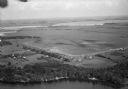
| Description: | Aerial view of Pennco Field (Royal Airport), the shoreline of Lake Monona, and the surrounding countryside near the city limits. |

| Date: | 11 19 1970 |
|---|---|
| Description: | Exterior view of the uniquely designed house of Byron Bloomfield at 1010 Edgehill Drive in Shorewood Hills, which is built into the side of a sharp slope. ... |
| Date: | 11 24 1898 |
|---|---|
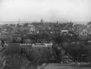
| Description: | View from Bascom Hill toward the Wisconsin State Capitol showing the Wisconsin Historical Society under construction. |
| Date: | 1900 |
|---|---|
| Description: | View across Lake Mendota towards the lower campus buildings at the University of Wisconsin-Madison. |

| Date: | 1906 |
|---|---|
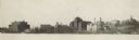
| Description: | Shacks at the foot of North Main Street along Lake Monona near what later became Brittingham Park. |

| Date: | 1906 |
|---|---|
| Description: | Area at the foot of West Main Street, which is now Brittingham Park. Weatherworn buildings are on the right. |

| Date: | 1909 |
|---|---|
| Description: | View from Sunset Point in Owen Park, which is now a part of Hoyt Park. Lake Mendota is in the distance. |

| Date: | 1909 |
|---|---|
| Description: | View from the University of Wisconsin service building smokestack of south Madison, including Mills Street, Mound Street, and the Greenbush. Lake Monona is... |
| Date: | 01 07 1973 |
|---|---|
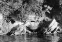
| Description: | The legendary Black Hawk Cave on the south shore of Lake Mendota, where Black Hawk allegedly hid from white troopers during the Black Hawk War. |
| Date: | |
|---|---|
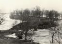
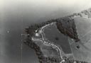
| Description: | An aerial view of Second Point on Lake Mendota. |
| Date: | |
|---|---|
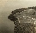
| Description: | An aerial view of second point on Lake Mendota. |
| Date: | |
|---|---|
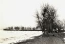
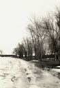
| Description: | The northern shore of Picnic Point in the middle of winter. |

| Date: | |
|---|---|
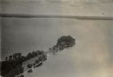
| Description: | An aerial view of both Picnic Point and Second Point looking toward the isthmus. Members of the Jackson Family had summer homes at Second Point at this tim... |
If you didn't find the material you searched for, our Library Reference Staff can help.
Call our reference desk at 608-264-6535 or email us at: