Filter: Categories of Wisconsin Historical Images
Filter: Subject of Land
Filter: County of Dane
Filter: Year of 1800-1899
Filter: Categories of Wisconsin Historical Images
Filter: Subject of Land
Filter: County of Dane
Filter: Year of 1800-1899
| Date: | 08 07 1885 |
|---|---|
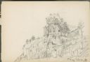
| Description: | House on rock outcropping. The house has two chimneys and is two stories high with porch at left, three windows on first story, one visible on second story... |
| Date: | 1885 |
|---|---|
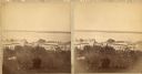
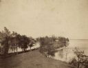
| Description: | A view of Lake Monona from the Capitol building, looking down King Street. |
| Date: | 1898 |
|---|---|
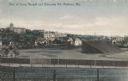
| Description: | View over Camp Randall Stadium towards University Hill on the University of Wisconsin-Madison campus. Bascom Hall is visible in the distance. Caption reads... |

| Date: | 1888 |
|---|---|
| Description: | View of Picnic Point stretching out into Lake Mendota on the University of Wisconsin-Madison campus. |
| Date: | 1888 |
|---|---|
| Description: | View of Picnic Point on the University of Wisconsin-Madison campus. The peninsula juts into Lake Mendota. The far shoreline can be seen in the distance. |

| Date: | 11 24 1898 |
|---|---|
| Description: | Elevated view from the top of Main Hall (later Bascom Hall) of Picnic Point on Lake Mendota from the University of Wisconsin-Madison campus. |

| Date: | 1876 |
|---|---|
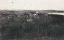
| Description: | Elevated view of building on the University of Wisconsin-Madison campus, which is located on a hill near Lake Mendota. A winding drive leads up to the hous... |

| Date: | 04 1896 |
|---|---|
| Description: | View from Chi Psi porch on the University of Wisconsin-Madison campus. Picnic Point is stretching towards the right in the far background. There appears to... |
| Date: | 1898 |
|---|---|
| Description: | Elevated view over trees towards the west of Upper Campus at the University of Wisconsin. Washburn Observatory, with windmills behind it, is on the right n... |

| Date: | 1873 |
|---|---|
| Description: | Color outline map of Dane County, Wisconsin. |
| Date: | 1897 |
|---|---|
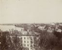
| Description: | Elevated view of North Hall on the University of Wisconsin-Madison campus. Science Hall, Lake Mendota and the city of Madison on the isthmus are visible in... |
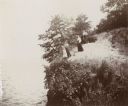
| Date: | 1894 |
|---|---|
| Description: | Elevated view of three women and a young girl standing at the edge of a small cliff on the shores of Lake Mendota. Various shrubs and small trees grow on t... |
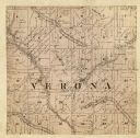
| Date: | 1861 |
|---|---|
| Description: | A map of the Verona Township, which is a section of a larger Dane County map. |
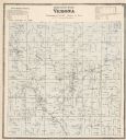
| Date: | 1873 |
|---|---|
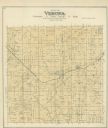
| Description: | A map of Verona Township from the Dane County Atlas. |

| Date: | 1890 |
|---|---|
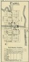
| Description: | A plat map of a portion of Verona in Dane County. |
If you didn't find the material you searched for, our Library Reference Staff can help.
Call our reference desk at 608-264-6535 or email us at: