 Filter: Categories of Wisconsin Historical Images
Filter: Subject of Land
Filter: County of Dane
Filter: Subject of human settlements
Filter: Categories of Wisconsin Historical Images
Filter: Subject of Land
Filter: County of Dane
Filter: Subject of human settlements
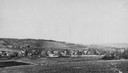
| Date: | 1910 |
|---|---|
| Description: | View from hill looking down at Cross Plains. |
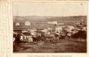
| Date: | 1905 |
|---|---|
| Description: | Elevated view of the town. Caption reads: "Part of Deerfield, Wis. -- viewed from the East". Handwritten note: "Dear Ella, Here comes the postal I am owing... |
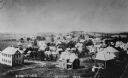
| Date: | 1915 |
|---|---|
| Description: | Elevated view of DeForest. Caption reads: "Birdseye View, DeForest, Wis." |

| Date: | 1928 |
|---|---|
| Description: | Aerial view of Madison looking southeast over the isthmus, showing the Four Lakes Country. Visible at the bottom is the Lake Mendota shoreline. At center, ... |

| Date: | 1956 |
|---|---|
| Description: | Aerial view looking northeast from a point over the east end of Middleton, showing the west end of Lake Mendota (right mid-ground). Fox Bluff juts into the... |

| Date: | 1955 |
|---|---|
| Description: | An air view of Madison's downtown area with the Wisconsin State Capitol and new State Office Buildings. |

| Date: | 1950 |
|---|---|
| Description: | Aerial view of the Madison isthmus looking north. Caption reads: "Madison Wisconsin — Between Lake Mendota and Lake Monona". |

| Date: | 1924 |
|---|---|
| Description: | Aerial view of Madison's Willow Beach towards the University of Wisconsin-Madison campus, downtown Madison, and Lake Monona. |

| Date: | 1919 |
|---|---|
| Description: | Aerial view with the Wisconsin State Capitol in the foreground, and the tip of Monona Bay and Lake Wingra to the left, with horizon stretching into the dis... |

| Date: | 1930 |
|---|---|
| Description: | Aerial view of isthmus looking east toward Lake Mendota and the Wisconsin State Capitol, with Lake Monona and the horizon in the background. |

| Date: | 07 06 1937 |
|---|---|
| Description: | Aerial view of the west central part of isthmus and the University of Wisconsin campus. |
| Date: | 1938 |
|---|---|
| Description: | View of the Belmont Hotel from the Capitol Grounds. Hommel Bros., with "Good Things to Eat," is on the corner at 20 West Mifflin Street. |
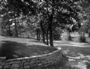
| Date: | 06 16 1949 |
|---|---|
| Description: | Road and stone retaining wall in front of Freda Winterble property, 901 University Bay Drive, looking toward the Timlin Lumber Company, 2702 University Ave... |

| Date: | 06 16 1949 |
|---|---|
| Description: | Freda Winterble property, 901 University Bay Drive, looking north toward Lake Mendota. In the distance a man is holding a white rope to show where the new ... |
| Date: | 06 16 1949 |
|---|---|
| Description: | Slightly elevated view of the Freda Winterble property, 901 University Bay Drive, with white rope showing where new road will require the cutting down of l... |

| Date: | 1947 |
|---|---|
| Description: | The Black Hawk Golf Course green, sans golfers. |

| Date: | 06 16 1949 |
|---|---|
| Description: | Freda Winterble property, 901 University Bay Drive, on left of road, looking south down the Drive to University Avenue. |

| Date: | 06 16 1949 |
|---|---|
| Description: | Freda Winterble property, 901 University Bay Drive, looking north toward Lake Mendota, showing trees on right side of road and house on the left, 928 Unive... |

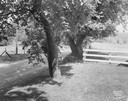
| Date: | 06 16 1949 |
|---|---|
| Description: | Freda Winterble property, 901 University Bay Drive, looking north toward Lake Mendota, showing large trees on adjoining property. |

| Date: | 1911 |
|---|---|
| Description: | Plat Map of Blooming Grove in "Atlas of Dane County, Wisconsin." |
If you didn't find the material you searched for, our Library Reference Staff can help.
Call our reference desk at 608-264-6535 or email us at: