Filter: Categories of Wisconsin Historical Images
Filter: Subject of Land
Filter: County of Dane
Filter: Subject of botany
Filter: Categories of Wisconsin Historical Images
Filter: Subject of Land
Filter: County of Dane
Filter: Subject of botany

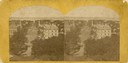
| Date: | 1874 |
|---|---|
| Description: | Distant view of the town from a hill with houses, garden plots, businesses and churches. |

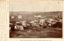
| Date: | 1874 |
|---|---|
| Description: | Elevated view from hill of Clinton, now Rockdale. Three men are in the middle distance, looking east across Koshonong Creek towards a mill dam, bridge and ... |
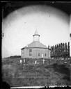
| Date: | 1878 |
|---|---|
| Description: | West Koshkonong Lutheran Church and cemetery. Octagonal stone church built in 1852, rebuilt in 1893, seating 800 people. |
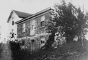
| Date: | 1876 |
|---|---|
| Description: | "Reverend A. Jacobson's residence, distance" from Dahl's 1877 "Catalogue of Stereoscopic Views." |
| Date: | 1876 |
|---|---|
| Description: | Elevated view from the Wisconsin State Capitol looking north to Lake Mendota along Wisconsin Avenue. City Hall is on the left, built in 1858, and the Feder... |
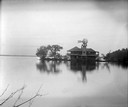
| Date: | 1915 |
|---|---|
| Description: | Rocky Roost, west of Governor's Island in Lake Mendota. The structure was designed by Frank Lloyd Wright for his childhood friend Robert Lamp. The home's ... |
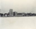
| Date: | 12 18 1955 |
|---|---|
| Description: | Downtown Madison lakeshore taken from Lake Monona in a line with South Carroll Street. Includes State Office Building (2 wings only), 1 West Wilson Street,... |
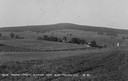
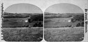
| Date: | |
|---|---|
| Description: | View of farmland near Blue Mounds, with possibly property markers horizontal, across the center, and some distant farm houses and a barn. Caption reads: "B... |
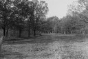
| Date: | 1930 |
|---|---|
| Description: | View of a wide path through trees in the spring or summer. |
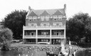
| Date: | 1915 |
|---|---|
| Description: | Exterior front view from Lake Mendota of the Delta Upsilon Fraternity House, located at 640 North Francis Street, erected in 1906. A group of people are o... |

| Date: | 05 10 1928 |
|---|---|
| Description: | The Lutheran Church and buildings, seen from Lutheran Church Hill. |
| Date: | 1860 |
|---|---|
| Description: | Elevated view of multiple buildings in Cross Plains from Lutheran Church Hill. Many roads and fences cross the fields. Wooded hills are in the background. ... |
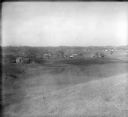
| Date: | 1928 |
|---|---|
| Description: | View from hill of uptown Cross Plains with the Catholic Church (St. Francis Xavier) and farmhouses. |

| Date: | 1955 |
|---|---|
| Description: | Aerial view of Cross Plains, with countryside surrounding and hills on the horizon. |
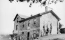
| Date: | 1925 |
|---|---|
| Description: | Berry Haney house, located about a mile east of Cross Plains. The stone portion of the house was built in 1840. |
| Date: | 1910 |
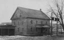
|---|---|
| Description: | Exterior view of the Roller Mill with a covered loading dock. A sign on the end of the building at the roof line reads: "Roller Mill." Trees and power pole... |
| Date: | 1905 |
|---|---|
| Description: | Elevated view of the town. Caption reads: "Part of Deerfield, Wis. -- viewed from the East". Handwritten note: "Dear Ella, Here comes the postal I am owing... |

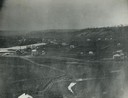
| Date: | 1956 |
|---|---|
| Description: | Aerial view looking northeast from a point over the east end of Middleton, showing the west end of Lake Mendota (right mid-ground). Fox Bluff juts into the... |
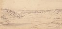
| Date: | 1852 |
|---|---|
| Description: | Pencil drawing of Black Earth Valley. Gentle lightly tree-covered hills frame the center grassy valley. Two farmhouses are sitting at the base of hills on ... |
If you didn't find the material you searched for, our Library Reference Staff can help.
Call our reference desk at 608-264-6535 or email us at: