 Filter: Categories of Wisconsin Historical Images
Filter: Subject of Land
Filter: County of Columbia
Filter: Subject of railroads
Filter: Categories of Wisconsin Historical Images
Filter: Subject of Land
Filter: County of Columbia
Filter: Subject of railroads
| Date: | |
|---|---|
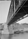
| Description: | View of the river and the underside of a railroad bridge at Kilbourn. There is a building in the background on the right just above the cliffs along the ri... |
| Date: | |
|---|---|
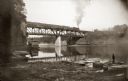
| Description: | Chicago, Milwaukee and St. Paul passenger train on Kilbourn railroad bridge. "Apollo No. 1" steamboat below bridge, with musicians in bow. Various launch b... |
| Date: | |
|---|---|
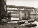
| Description: | Bridge over river with railroad train. "Apollo No. 1" steamboat under bridge. Boats are along the shoreline. |
| Date: | |
|---|---|
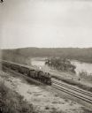
| Description: | Elevated view of a train running parallel to the river, past the Ink Stand. Several people are standing along the tracks and waving. |

| Date: | 1868 |
|---|---|
| Description: | This 1868 birds-eye view depicts the buildings, streets, railroad, vegetation and topography of Columbus, Wisconsin. The high school, cemetery, railroad de... |

| Date: | 1878 |
|---|---|
| Description: | View from riverbank of the Chicago Milwaukee and St. Paul railroad locomotive no. 142 on the Kilbourn bridge. |

| Date: | 1861 |
|---|---|
| Description: | This 1861 map of Columbia County, Wisconsin, shows the township and range grid, towns, sections, cities and villages, railroads, roads, property owners and... |

| Date: | 1856 |
|---|---|
| Description: | This map shows plat of town, local streets, railroads, projected railroads, residential buildings, mills, and part of the Crawfish River. The map includes ... |

| Date: | 1856 |
|---|---|
| Description: | This plat shows block and lot numbers and land reserved for a railroad and passenger depot. The map includes certifications and registration. Kilbourn City... |

| Date: | 1960 |
|---|---|
| Description: | This map includes a sheet index showing streets, proposed streets, the high school, and railroad. |
If you didn't find the material you searched for, our Library Reference Staff can help.
Call our reference desk at 608-264-6535 or email us at: