 Filter: Categories of Wisconsin Historical Images
Filter: Subject of Land
Filter: Community of West Bend
Filter: Categories of Wisconsin Historical Images
Filter: Subject of Land
Filter: Community of West Bend

| Date: | |
|---|---|
| Description: | This map shows land parcels, streets and parks in the city of West Bend. The Milwaukee River is labeled on the left side. |
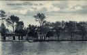
| Date: | 1908 |
|---|---|
| Description: | View across lake towards three guest cabins under trees on the shoreline near a pier. The main building is on the hill behind. Caption reads: "Wolfrum's Re... |
If you didn't find the material you searched for, our Library Reference Staff can help.
Call our reference desk at 608-264-6535 or email us at: