 Filter: Categories of Wisconsin Historical Images
Filter: Subject of Land
Filter: Community of Wausau
Filter: Categories of Wisconsin Historical Images
Filter: Subject of Land
Filter: Community of Wausau
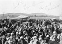
| Date: | 1928 |
|---|---|
| Description: | The groundbreaking ceremony for the new airport hangar at Wausau. Governor Fred R. Zimmerman, who can be seen on the right, (elevated above the crowd and w... |

| Date: | 1879 |
|---|---|
| Description: | This map is a bird's-eye view of Wausau, the County Seat of Marathon County. The map features an index of points of interest. |
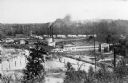
| Date: | |
|---|---|
| Description: | Elevated view of the Wausau paper mills, with smokestacks in the center, and trees and water in the foreground. |
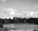
| Date: | 1945 |
|---|---|
| Description: | View of the Wausau Memorial Hospital, with the Wisconsin River in the foreground. |
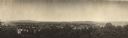
| Date: | 1900 |
|---|---|
| Description: | Panoramic elevated view over trees towards a residential area in Wausau, Wisconsin. Hills are in the distance. |
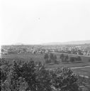
| Date: | 1912 |
|---|---|
| Description: | Elevated view of Wausau from the edge of town looking toward residences and businesses. Hills are in the far background. |
| Date: | 1912 |
|---|---|
| Description: | Winter view over fields of town with hills in the far background. |
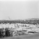
| Date: | 1905 |
|---|---|
| Description: | Elevated view of Wausau with the residential area in the foreground and a business district in the background. Caption reads: "A View of Wausau, Wis." |

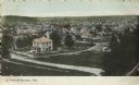
| Date: | 1900 |
|---|---|
| Description: | View of the Stewart residence from the road. There is a stone wall along the sidewalk and a gate in front of the walkway to the front steps. |
| Date: | 1905 |
|---|---|
| Description: | Elevated view toward the lumber company. A bridge over a river is in the foreground. Caption reads: "Looking South from City Hall Tower, Wausau, Wis." |
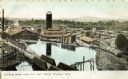
| Date: | 1930 |
|---|---|
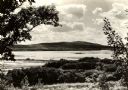
| Description: | View looking west at Rib Mountain across the Wisconsin River from the outskirts of Wausau. |

| Date: | 1905 |
|---|---|
| Description: | View across water toward East Hill. Caption reads: "East Hill, from Depot Grounds, Wausau, Wis." |
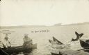
| Date: | 08 05 1922 |
|---|---|
| Description: | Two fishermen on a lake catch a giant fish. Both of the fishermen are wearing hats and one is smoking a pipe. A dock and the tip of a boat are in the foreg... |
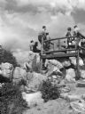
| Date: | 1936 |
|---|---|
| Description: | A view from below of a lookout area filled with visitors on Rib Mountain. |
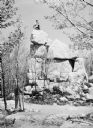
| Date: | |
|---|---|
| Description: | View from below of a man, sitting atop a large rock pile/quarry in the vicinity of Wausau. |
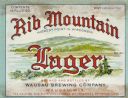
| Date: | 1938 |
|---|---|
| Description: | Label submitted to the state of Wisconsin for trademark registration. "Rib Mountain Lager, Highest Point in Wisconsin, Brewed and Bottled by Wausau Brewing... |
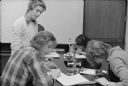
| Date: | 1978 |
|---|---|
| Description: | Students at Wausau West High School involved in an innovative science project that studied energy consumption and pollution of the Wisconsin River. |

| Date: | 06 1987 |
|---|---|
| Description: | Congressman David Obey of Wisconsin biking with the Wausau Wheelers. |
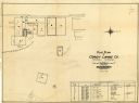
| Date: | 1928 |
|---|---|
| Description: | This plat map of Wausau is oriented with north to the right and is dated "April, 1928." The map features a building description chart with an index and inc... |
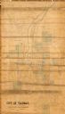
| Date: | 1892 |
|---|---|
| Description: | This map shows lot and block numbers and dimensions, some landownership, wards, railroads, streets, and mills. The map includes 5 plat additions that have ... |
If you didn't find the material you searched for, our Library Reference Staff can help.
Call our reference desk at 608-264-6535 or email us at: