 Filter: Categories of Wisconsin Historical Images
Filter: Subject of Land
Filter: Community of Waukesha
Filter: Categories of Wisconsin Historical Images
Filter: Subject of Land
Filter: Community of Waukesha
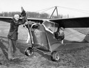
| Date: | 1932 |
|---|---|
| Description: | Fritz Warden (at the propeller) and Lee Barney, two young members of the Waukesha Flying Club, together with Barney's Aeronica C2 airplane. The Aeronica w... |

| Date: | 1880 |
|---|---|
| Description: | Bird's-eye map of Waukesha, county seat of Waukesha County. |

| Date: | 1890 |
|---|---|
| Description: | Colored bird's-eye map of Oconomowoc and the Lake Region, Waukesha County. Looking North from Government Hill. Location key below image identifies 24 Hotel... |
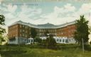
| Date: | 1910 |
|---|---|
| Description: | Exterior view of the Rest Haven Sanitarium. Caption reads: "Rest Haven Sanitarium, Waukesha, Wis." |
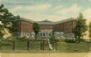
| Date: | 1912 |
|---|---|
| Description: | Exterior view of Resthaven, a sanitarium. Caption reads: "Resthaven, Waukesha, Wis." |
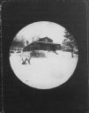
| Date: | 1890 |
|---|---|
| Description: | Round-framed view of the house in which Rev. A.L. Lindsley and his family lived in 1846. In it were born Julia West, Addison Alexander, and Justus (who die... |

| Date: | 08 23 1917 |
|---|---|
| Description: | Man, possibly Joseph Brown, attending to an automobile on the road between Waukesha and Ionsman. Rural landscape and farm in the background. |

| Date: | 1953 |
|---|---|
| Description: | Map shows landownership and acreages, roads, and railroads in the Town of Waukesha and part of the city of Waukesha, Waukesha County, Wisconsin. |

| Date: | 1846 |
|---|---|
| Description: | This map of Prairieville, later renamed Waukesha, is ink and pencil on paper and shows the Fox River, a plat of village, and lot owners. |

| Date: | 1871 |
|---|---|
| Description: | This map of Waukesha shows lot owners, buildings, and various plat additions. The margins of the maps include street reference, a Waukesha business directo... |

| Date: | 1962 |
|---|---|
| Description: | This map shows the voting districts of Waukesha in red ink for the year 1962. The bottom of the map includes an index of streets. |
If you didn't find the material you searched for, our Library Reference Staff can help.
Call our reference desk at 608-264-6535 or email us at: