 Filter: Categories of Wisconsin Historical Images
Filter: Subject of Land
Filter: Community of Superior
Filter: Categories of Wisconsin Historical Images
Filter: Subject of Land
Filter: Community of Superior
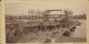
| Date: | 09 19 1892 |
|---|---|
| Description: | Captain Alexander McDougall's whaleback passenger steamer "Christopher Columbus" under construction in the shipyard of the American Steel Barge Company in ... |

| Date: | 1883 |
|---|---|
| Description: | Bird's-eye map of Superior, county seat of Douglas County, on the shores of Lake Superior, with insets of points of interest. |

| Date: | 1913 |
|---|---|
| Description: | Bird's-eye map of Superior. "The New Steel Center." |

| Date: | 1915 |
|---|---|
| Description: | Bird's-eye view of Superior, Wisconsin, and Duluth, Minnesota on opposite shore of Lake Superior. |

| Date: | 1913 |
|---|---|
| Description: | Aerial bridge and harbor, with a large boat passing underneath. A lamppost and a beacon are along the walkway towards the bridge on the left. Caption reads... |

| Date: | 1960 |
|---|---|
| Description: | Aerial view with docks in the foreground. Caption reads: "Superior, Wisconsin." |
| Date: | 1938 |
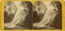
|---|---|
| Description: | Little Manitou Falls on the Black River. Referred to as the "upper falls" in the park. A person is sitting on the rocks on top of the falls. This waterfall... |
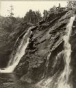
| Date: | 1890 |
|---|---|
| Description: | Stereograph of Big Manitou Falls on the Black River. This waterfall reportedly was called "Gitchee Monido" by the Ojibwa, which means "Falls of the Great S... |

| Date: | 1890 |
|---|---|
| Description: | Big Manitou Falls on the Black River. This waterfall reportedly was called "Gitchee Monido" by the Ojibwa, which means "Falls of the Great Spirit." |
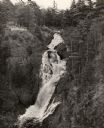
| Date: | 1940 |
|---|---|
| Description: | Big Manitou Falls on the Black River. It is referred to as the "lower falls" in the park. This 165-foot waterfall is recognized as the highest in the state... |

| Date: | 1911 |
|---|---|
| Description: | This map, taken from the 1911 Map of Wisconsin showing geology and roads by Hotchkiss and Thwaites, shows the northwest portion of Douglas County, Wisconsi... |

| Date: | 1909 |
|---|---|
| Description: | This map shows Duluth, Minnesota and Superior, Wisconsin, and portions of Saint Louis County, Minnesota and Douglas County, Wisconsin. Water depth is shown... |

| Date: | 1925 |
|---|---|
| Description: | This map of Howard's Bay located at the Duluth Superior Harbor is a close view of Connors Point and shows a key to prevailing winds and water depth measure... |

| Date: | 1934 |
|---|---|
| Description: | This map shows industrial points of interest in Superior. The top of the map reads: "Superior, Douglas County, Wisconsin, as this Industrial Tour map indic... |

| Date: | 1887 |
|---|---|
| Description: | This map shows lot and block numbers, established dock lines, docks, slips, railroads, and streets of West Superior in 1887. |

| Date: | 1889 |
|---|---|
| Description: | This map shows lot and block numbers, established dock lines, docks, slips, railroads, and streets of West Superior in 1889. |

| Date: | 1891 |
|---|---|
| Description: | This colorful map shows additions, railroads, docks, streets, established dock lines, marshes, and proposed belt line railroad. The map covers west and sou... |

| Date: | 1894 |
|---|---|
| Description: | This map shows lot and block numbers, railroads, street car tracks, sewers, water mains, gas mains, paved streets, land owned by the Land & River Improveme... |
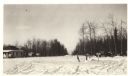
| Date: | 01 31 1936 |
|---|---|
| Description: | View across snow towards a concession building on the left and a parked truck on the right. Caption on back reads: "Concession building is at the left. The... |
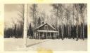
| Date: | 01 31 1936 |
|---|---|
| Description: | The description on the back reads: "The custodian building in Pattison Park which will not conform with the Combination building 200 feet away if the latte... |
If you didn't find the material you searched for, our Library Reference Staff can help.
Call our reference desk at 608-264-6535 or email us at: