 Filter: Categories of Wisconsin Historical Images
Filter: Subject of Land
Filter: Community of Sparta
Filter: Categories of Wisconsin Historical Images
Filter: Subject of Land
Filter: Community of Sparta

| Date: | 1940 |
|---|---|
| Description: | This maps shows the areas in Monroe, Jackson, and Juneau counties, Wisconsin, where U.S. Army maneuvers were held in August 1940. Highways and roads, commu... |
| Date: | |
|---|---|
| Description: | View of Camp Robinson towards an open area with cannons grouped together in the center between rows of horses under shelters. There are wagons on the right... |
| Date: | |
|---|---|
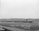
| Description: | Elevated view of Fort McCoy with rows of tents among trees. There is a row of automobiles parked in the center, and a row of barracks on the left. Caption ... |
| Date: | |
|---|---|
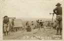
| Description: | Photographic postcard view of a group of surveyors working on a hilltop at Camp McCoy. Caption reads: "O. P. Camp McCoy, Sparta, Wis." |

| Date: | 05 26 1947 |
|---|---|
| Description: | View across road and fields towards three wooded hill peaks. A roadside fence is in the foreground. Caption reads: "D.A. 36-268 — Three peaks on Hy.71 betw... |
| Date: | |
|---|---|
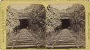
| Description: | View down railroad tracks towards two men working near the entrance to a tunnel. The man on the left is using a pick, the other man is using a shovel. Wate... |
| Date: | 1907 |
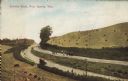
|---|---|
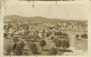
| Description: | Text on front reads: "County Road, Near Sparta, Wis." Elevated view of a group of people standing on an unpaved county road that runs through a cut in a hi... |

| Date: | 1904 |
|---|---|
| Description: | Text on front reads: "Castle Rock near Sparta, Wis." A formation about 600 feet high, having on its summit a large circular rock, named Castle Rock, for it... |
If you didn't find the material you searched for, our Library Reference Staff can help.
Call our reference desk at 608-264-6535 or email us at: