 Filter: Categories of Wisconsin Historical Images
Filter: Subject of Land
Filter: Community of Seneca
Filter: Categories of Wisconsin Historical Images
Filter: Subject of Land
Filter: Community of Seneca

| Date: | |
|---|---|
| Description: | This 19th century manuscript map shows the township and range systems, sections, and acreages along the Mississippi River in the towns of Freeman and Senec... |
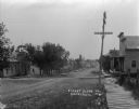
| Date: | 1912 |
|---|---|
| Description: | View down unpaved street with a school building on the left on the opposite side of the street. A board sidewalk leads to a two-story dwelling on the right... |
| Date: | 1912 |
|---|---|
| Description: | A scenic view over rolling hills with a road leading to the horizon. There are trees, fields and farm buildings on the left. In the foreground on the right... |
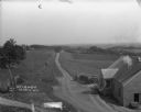
| Date: | 08 1940 |
|---|---|
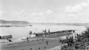
| Description: | Elevated view of a coal barge pushed by a stern wheeled steamboat heading upstream from the Mississippi River Lock and Dam No. 9 north of Prairie du Chien,... |
If you didn't find the material you searched for, our Library Reference Staff can help.
Call our reference desk at 608-264-6535 or email us at: