 Filter: Categories of Wisconsin Historical Images
Filter: Subject of Land
Filter: Community of Primrose
Filter: Categories of Wisconsin Historical Images
Filter: Subject of Land
Filter: Community of Primrose
| Date: | |
|---|---|
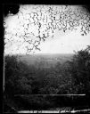
| Description: | View over trees towards a farm and fields, possibly those of G. Tollefson. |
| Date: | |
|---|---|
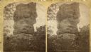
| Description: | View of the rock formation named Devil's Chimney. A quotation on the back of the stereograph reads, "A rock 50 feet high, 25 feet diameter at the base and ... |
| Date: | |
|---|---|
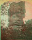
| Description: | View of the rock formation named Devil's Chimney. A quotation on the back of the stereograph reads, "A rock 50 feet high, 25 feet diameter at the base and ... |

| Date: | 1873 |
|---|---|
| Description: | A map of the township of Primrose from the "Atlas of Dane County." |

| Date: | 1861 |
|---|---|
| Description: | The township of Primrose, which is a detail from the plat map of Dane County. |
| Date: | 06 28 1964 |
|---|---|
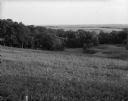
| Description: | View across a field sloping down toward a woodland area, with fields and hills in the distance. Caption reads: "Primrose (vicinity), Wis. June 28, 1960. Bi... |
If you didn't find the material you searched for, our Library Reference Staff can help.
Call our reference desk at 608-264-6535 or email us at: