Filter: Categories of Wisconsin Historical Images
Filter: Subject of Land
Filter: Community of Platteville
Filter: Categories of Wisconsin Historical Images
Filter: Subject of Land
Filter: Community of Platteville

| Date: | 1875 |
|---|---|
| Description: | Bird's-eye map of Platteville. |
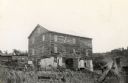
| Date: | 1940 |
|---|---|
| Description: | Hadley Mill on the Little Platte River, seven miles southwest of Platteville in the Town of Paris. |
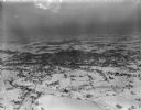
| Date: | 02 17 1949 |
|---|---|
| Description: | One of five aerial views of Platteville and surrounding countryside covered in snow. |
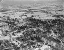
| Date: | 02 17 1949 |
|---|---|
| Description: | One of five aerial views of Platteville and surrounding countryside covered in snow. |
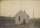
| Date: | |
|---|---|
| Description: | Small rural clapboard schoolhouse with class posing at entrance. There is a dog sitting on the right side of the building, and cows are in a field in the b... |

| Date: | 1960 |
|---|---|
| Description: | This street map was likely given out by Mound City Bank and features a legend of points of interest and a street index. Streets are labeled as is the Round... |

| Date: | 1906 |
|---|---|
| Description: | This topographical map shows the Little Platte River, shafts, test-pits, old workings, contour lines of Galena limestone elevation, railroads, and building... |
If you didn't find the material you searched for, our Library Reference Staff can help.
Call our reference desk at 608-264-6535 or email us at: