 Filter: Categories of Wisconsin Historical Images
Filter: Subject of Land
Filter: Community of Oshkosh
Filter: Categories of Wisconsin Historical Images
Filter: Subject of Land
Filter: Community of Oshkosh
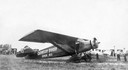
| Date: | 1932 |
|---|---|
| Description: | In order to undertake a trans-Atlantic flight to Norway, Clyde Allen Lee sought financial support from the local Oshkosh clothing company. The sign painted... |
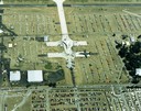
| Date: | 1988 |
|---|---|
| Description: | Aerial view of the 1988 EAA (Experimental Aviation Association) Convention and Fly-in at Wittman Field. On the ground is the Concorde and a B-1 Bomber. |

| Date: | |
|---|---|
| Description: | Captain John Henry Otto, (marked with X), along with another man from the 21st Wisconsin Infantry, posing on the top of Lookout Mountain, Tennessee. John H... |

| Date: | 1950 |
|---|---|
| Description: | This map of the business section of Oshkosh shows businesses and lot owners. The map is oriented with north to the left and includes 2 "continued inset" ma... |

| Date: | 09 1950 |
|---|---|
| Description: | This map show streets, points of interest, Lake Winnebago and bays, Lake Butte Des Morts, and the Fox River. The back of the map includes a directory of t... |

| Date: | 1962 |
|---|---|
| Description: | This map shows streets, points of interest, Lake Winnebago, Millers Bay, South Asylum Bay, Lake Butte des Morts, and the Fox River. The map also includes a... |

| Date: | 06 1890 |
|---|---|
| Description: | This map shows building use, railroads, tramways, lumber yards, roads, watchman’s stations, and steam pipes. Also included is text about buildings, Clapp a... |

| Date: | 1930 |
|---|---|
| Description: | This map shows city wards, streets, railroads, parks, Lake Butte Des Morts, Lake Winnebago, advertisements for Dixie Oils Gasoline, a list of Cook & Brown ... |

| Date: | 1858 |
|---|---|
| Description: | This map shows city wards, streets, block and lot numbers, cemeteries, buildings, landownership, forests, railroads, a race course, quarries, and orchards.... |

| Date: | 1877 |
|---|---|
| Description: | This map shows the Fox River, Lake Winnebago, city wards, lot and block numbers, landownership, selected buildings, railroads, and roads. There are three i... |

| Date: | 1908 |
|---|---|
| Description: | This blueprint map is showing subdivisions and additions. Streets, rivers, and land plots are labeled. |
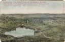
| Date: | 1908 |
|---|---|
| Description: | Illustrated postcard of Lake Winnebago and the surrounding communities. Text on front reads: "Looking northwest from the east shore of Lake Winnebago showi... |
If you didn't find the material you searched for, our Library Reference Staff can help.
Call our reference desk at 608-264-6535 or email us at: