 Filter: Categories of Wisconsin Historical Images
Filter: Subject of Land
Filter: Community of Neenah
Filter: Categories of Wisconsin Historical Images
Filter: Subject of Land
Filter: Community of Neenah
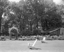
| Date: | 06 16 1963 |
|---|---|
| Description: | Garden, entrance to swimming pool, and pavilion at the Donald Shepard residence, originally the Smith house, built by the son of the founder of the Menasha... |

| Date: | 1910 |
|---|---|
| Description: | Doty's Loggery. Caption printed under image reads: "Governor James Duane Doty, in 1845, built this log house on Doty's Island (Menasha), and resided there ... |

| Date: | 1876 |
|---|---|
| Description: | This map is of the towns of Neenah and Menasha and shows existing and proposed canals. Water depths shown by soundings. Little Butte des Morts Lake, Doty I... |

| Date: | 1936 |
|---|---|
| Description: | This map of Neenah and Menasha shows some parks, churches, convention halls, and other buildings. These points of interest are in red ink. Streets, Little ... |

| Date: | 1903 |
|---|---|
| Description: | This maps shows what may be Ho Chunk Native American burial mounds. Also noted on the map is the Fox River, the Doty homestead, stockade embankment, the We... |

| Date: | 1846 |
|---|---|
| Description: | This plat map, which features the very early spelling of Wisconsin as "Wiskonsin", was created sometime between 1846 and 1854 and shows a canal and dam on ... |

| Date: | 1840 |
|---|---|
| Description: | This map shows a line of proposed construction for defending the north side of the canal against inundation from the Wisconsin River and location of Fort W... |
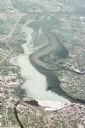
| Date: | 05 18 1970 |
|---|---|
| Description: | Aerial view titled "Neenah Pollution." The view is looking north from over Neenah at Little Lake Butte des Morts which is discolored. |
If you didn't find the material you searched for, our Library Reference Staff can help.
Call our reference desk at 608-264-6535 or email us at:

