 Filter: Categories of Wisconsin Historical Images
Filter: Subject of Land
Filter: Community of Mineral Point
Filter: Categories of Wisconsin Historical Images
Filter: Subject of Land
Filter: Community of Mineral Point

| Date: | 1890 |
|---|---|
| Description: | View looking down railroad tracks towards the Chicago, Milwaukee and St. Paul Railroad locomotive #240, a type 4-4-0. On the right is a steep, rocky bank, ... |

| Date: | 1840 |
|---|---|
| Description: | A hand-drawn plat map of Mineral Point, Wisconsin showing street layout and location of buildings. |
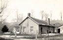
| Date: | 1940 |
|---|---|
| Description: | A Cornish home in Mineral Point. In the background is a small hill with trees. |

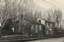
| Date: | 1930 |
|---|---|
| Description: | The home of a Cornish miner in Mineral Point. Houses are on a hill in the background. |
| Date: | 1925 |
|---|---|
| Description: | View from road looking down slope toward the house of a Cornish miner. Other buildings are in the background on the right. |
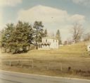
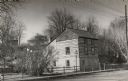
| Date: | 12 1971 |
|---|---|
| Description: | An abandoned farm house located on Highway 39 between Linden and Mineral Point. |
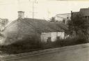
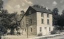
| Date: | 1935 |
|---|---|
| Description: | The Harris Cottage, north elevation, or rear of house. |

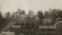
| Date: | 1955 |
|---|---|
| Description: | An aerial view of Mineral Point showing the construction of State Highway 23-39. |
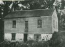
| Date: | |
|---|---|
| Description: | The Pendarvis house, a Cornish home on Shake Rag Street. |
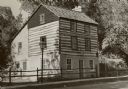
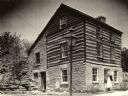
| Date: | 1940 |
|---|---|
| Description: | A restored Cornish miner's house, called Polperro, on Shake Rag Street. The house was temporarily covered with siding, but after restoration the siding was... |
| Date: | 1945 |
|---|---|
| Description: | A restored Cornish miner's house, called Polperro, on Shake Rag Street. The house was temporarily covered with siding, but after restoration the siding was... |
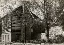
| Date: | 1953 |
|---|---|
| Description: | A restored Cornish miner's house, called Polperro, on Shake Rag Street. The house was temporarily covered with siding, but after restoration the siding was... |

| Date: | 1955 |
|---|---|
| Description: | A restored Cornish miner's house, called Polperro, on Shake Rag Street. The house was temporarily covered with siding, but after restoration the siding was... |
| Date: | 1945 |
|---|---|
| Description: | A restored Cornish miner's house, called Polperro, on Shake Rag Street. The house was temporarily covered with siding, but after restoration the siding was... |
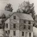
| Date: | |
|---|---|
| Description: | A drawing of the restored Cornish miner's house, called Polperro, on Shake Rag Street. The house was temporarily covered with siding, but after restoration... |
| Date: | 1940 |
|---|---|
| Description: | A woman demonstrating how Shake Rag Street got its name, with the restored Cornish miner's house, called Polperro, behind her. The house was temporarily co... |
| Date: | 1870 |
|---|---|
| Description: | View over rooftops towards the primitive Methodist Church, which is surrounded by homes. |
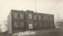
| Date: | 1925 |
|---|---|
| Description: | Lower Ward School (also called Second Ward School) built in 1867 and used through 1923. It was torn down in 1931. |

| Date: | 1935 |
|---|---|
| Description: | Shake Rag Street, showing Cornish miner's homes. The street was formerly called Hoard Street in honor of Capt. R.C. Hoard who was stationed at Fort Defianc... |
If you didn't find the material you searched for, our Library Reference Staff can help.
Call our reference desk at 608-264-6535 or email us at:
