 Filter: Categories of Wisconsin Historical Images
Filter: Subject of Land
Filter: Community of Milwaukee
Filter: Categories of Wisconsin Historical Images
Filter: Subject of Land
Filter: Community of Milwaukee

| Date: | 1840 |
|---|---|
| Description: | Pen-and-ink on paper. Map shows 1840’s homes with owner names, a Native American cemetery, and other points of interest. Relief shown by hachures. Oriented... |

| Date: | 1927 |
|---|---|
| Description: | Street railway and motor bus map with a legend of "Street Car Line," "Auxiliary Bus Lines," and "Motor Bus Lines." The routes are numbered. The map reads: ... |

| Date: | 1800 |
|---|---|
| Description: | Map of additions to Milwaukee. Several of the additions are outlined in colors and many streets, waterways, and some landmarks are labelled. |

| Date: | 1900 |
|---|---|
| Description: | Map shows 6 types of zoning districts in Milwaukee township. There is a key identifying four types of land: "AGRICULTURAL," '"A" RESIDENCE.' '"B" RESIDENCE... |

| Date: | 1850 |
|---|---|
| Description: | Map showing Indian mounds and graves as well as ground cover types at Township 8, Range 22. There is an inset diagram of an effigy mound labeled "The Cross... |

| Date: | 1869 |
|---|---|
| Description: | Map shows townships and sections, landownership and acreages, buildings, and marshes. The map includes insets of Franklin, Hales Corners, Bay View, Oak Cre... |

| Date: | 1860 |
|---|---|
| Description: | Map shows meadows, forests, buildings, railroad, and lots south of part of the city of Milwaukee. Relief shown by hachures. Includes list of lot acreages. |
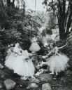
| Date: | 1958 |
|---|---|
| Description: | Girls of a visiting ballet company, in costume, posed in a rocky wooded glen along a stream. |

| Date: | 04 01 1958 |
|---|---|
| Description: | An antique 82-year-old horse-drawn hearse, pushed by pranksters into the Milwaukee River near the North Avenue bridge, being pulled out by a tow-truck, as ... |

| Date: | 1908 |
|---|---|
| Description: | Color postcard showing a landscape along River Park. |

| Date: | 03 27 1980 |
|---|---|
| Description: | Beekeeper Robert Neureuther examines a frame of honeycomb partly filled with honey. Behind him are hives wrapped up for cold weather. |

| Date: | 04 04 1934 |
|---|---|
| Description: | Street map of the city of Milwaukee and surrounding communities at a scale of 1 inch to 1200 feet. |

| Date: | 1902 |
|---|---|
| Description: | Two-wheeled show cart with pair of white show horses in tandem hitch, being driven by one person, probably along Lake Michigan. |
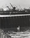
| Date: | 1964 |
|---|---|
| Description: | Docks at Jones Island with a lone swan swimming. Many large ships and city buildings can be seen in the background. |

| Date: | 1881 |
|---|---|
| Description: | Bird's-eye view of Milwaukee from the south lakeshore. |

| Date: | 1961 |
|---|---|
| Description: | Evacuation route out of Milwaukee. View from the side of the road looking downhill towards the rear of a Wisconsin State Patrol cruiser parked on the right... |
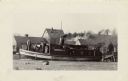
| Date: | 1931 |
|---|---|
| Description: | The Frank Braeger is moored on the shore of Jones Island with steam issuing from the pipe, with the crew posing on the boat. In the background a man... |

| Date: | 1931 |
|---|---|
| Description: | Fishermen from the Frank Braeger fishing tugboat are standing for a group portrait in front of their fishing nets on Jones Island. |

| Date: | 1931 |
|---|---|
| Description: | Two smiling fishermen stand before their fishing nets on Jones Island. There are floats attached to one net and a barrel with a jacket on top of it. |

| Date: | 1951 |
|---|---|
| Description: | This map is a survey of Lake Michigan and the section of Milwaukee that borders the lake. Map of land includes major streets, and landmarks near water. Rel... |
If you didn't find the material you searched for, our Library Reference Staff can help.
Call our reference desk at 608-264-6535 or email us at: