 Filter: Categories of Wisconsin Historical Images
Filter: Subject of Land
Filter: Community of Milwaukee
Filter: Categories of Wisconsin Historical Images
Filter: Subject of Land
Filter: Community of Milwaukee
| Date: | |
|---|---|
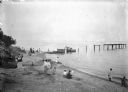
| Description: | Men, women, and children sitting and walking on the shore of a lake, possibly Lake Michigan, near a partially constructed pier. |

| Date: | 1914 |
|---|---|
| Description: | View of downtown Milwaukee riverbank before the First National Bank was built in 1914. Advertising painted on the sides of buildings includes B. Mock & So... |

| Date: | |
|---|---|
| Description: | The J. Robert Taylor family on what appears to be a lake shore, possibly cleaning fish. From left: Donna Taylor Adams, Alma Reinhardt Taylor, Fred Taylor, ... |

| Date: | 1905 |
|---|---|
| Description: | A woman, possibly Alma Reinhardt Taylor, wearing a long coat, on a rocky beach with a boy looking out at the water, and a younger child crouched at her fee... |
| Date: | 1905 |
|---|---|
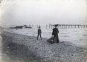
| Description: | A woman, possibly Alma Reinhardt Taylor, wearing a long coat, and a young boy and toddler walking along the rocky shoreline of what is probably Lake Michig... |
| Date: | |
|---|---|
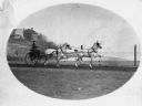
| Description: | A one-person carriage driven by a woman is led by two tandem horses stepping in rhythm and wearing blinders. A lake (probably Lake Michigan), and shoreline... |

| Date: | 05 14 1899 |
|---|---|
| Description: | Syl and aunt Helen standing on a small rustic wooden bridge in Gully Lake Park surrounded by trees and steep hills. |
| Date: | 1898 |
|---|---|
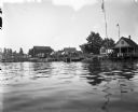
| Description: | View from water of boats docked near houses on Jones Island. To the right two flags are strung up flagpoles near a building with a covered porch, perhaps a... |
| Date: | 1898 |
|---|---|
| Description: | View across road of Syl standing in front of a three-story duplex house on Jones Island. |

| Date: | 1894 |
|---|---|
| Description: | Sanborn map of a portion of Milwaukee, including St. Clair and Bishop and Potter Avenues. There is an inset for the South Side Wood Working Co. |

| Date: | 1894 |
|---|---|
| Description: | Sanborn Map of the Illinois Steel Co. Bay View Works in Milwaukee. |

| Date: | |
|---|---|
| Description: | Letterhead of the Milwaukee Journal Tour Club, a national automobile club, with a three-quarter view of the company building surrounded by scenes of a hote... |

| Date: | 1933 |
|---|---|
| Description: | Label submitted to the state of Wisconsin for trademark registration. "Blatz, Old Heidelberg Castle, Beer, Blatz Brewing Co." Pictured on the label is a sc... |

| Date: | 07 02 1935 |
|---|---|
| Description: | Label submitted to the State of Wisconsin for trademark registration. Features a polar bear licking a large ice cream cone. There are floating blocks of ic... |

| Date: | 1836 |
|---|---|
| Description: | This hand-colored manuscript map shows the township and section grid in southeastern Wisconsin, covering the area west to Sugar River and Four Lakes region... |
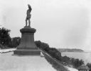
| Date: | 09 1900 |
|---|---|
| Description: | View of a statue in Juneau Park, created by American sculptor Anne Whitney in 1887. The statue is a replica of the original which resides in Boston, Massac... |

| Date: | |
|---|---|
| Description: | Stereograph elevated view from the dome of the Milwaukee Exposition Building looking south at the urban landscape. The cyclorama building in the foreground... |

| Date: | 1972 |
|---|---|
| Description: | These maps show the Milwaukee County supervisory districts as of April 1972 and the Supervisor and Assembly districts in effect prior to the April 1972 ele... |

| Date: | 1966 |
|---|---|
| Description: | This map from the 1960s provides a detailed street map of Milwaukee County and eastern Waukesha County as far west as Menomonee Falls and Muskego Lake. A p... |

| Date: | 1858 |
|---|---|
| Description: | An ink on paper map of Milwaukee County and the eastern portion of Waukesha County that shows the townships of Oak Creek, Franklin, Greenfield, Wauwatosa, ... |
If you didn't find the material you searched for, our Library Reference Staff can help.
Call our reference desk at 608-264-6535 or email us at: