 Filter: Categories of Wisconsin Historical Images
Filter: Subject of Land
Filter: Community of Mazomanie
Filter: Categories of Wisconsin Historical Images
Filter: Subject of Land
Filter: Community of Mazomanie
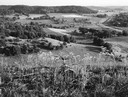
| Date: | 07 23 1960 |
|---|---|
| Description: | A view from bluffs, looking south, in the vicinity of Highway 78. |

| Date: | 1875 |
|---|---|
| Description: | Bird's-eye map of Mazomanie. |
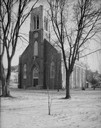
| Date: | 12 30 1930 |
|---|---|
| Description: | Exterior view of the St. Barnabas Catholic Church. Snow is on the ground. |

| Date: | 1874 |
|---|---|
| Description: | Distant view of the town from a hill with houses, garden plots, businesses and churches. |
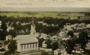
| Date: | 1907 |
|---|---|
| Description: | Elevated view of church and town. Caption reads: "Bird's-Eye View, Mazomanie, Wis." |

| Date: | 1910 |
|---|---|
| Description: | Elevated view of Mazomanie. The church's steeple stands out in the landscape of houses and barns. |

| Date: | |
|---|---|
| Description: | A path along railroad tracks on the left and a river on the right. Tall bushes are along the river. Trees and a fence are to the left lining the railroad t... |

| Date: | |
|---|---|
| Description: | Elevated view of Lake Marion, and the railroad tracks that run along it on the left. A train belching smoke is coming up the tracks. A road runs along the ... |

| Date: | 1913 |
|---|---|
| Description: | View from street of front of parsonage, a large two-story house with a gabled roof and a porch. There is a garden and stable behind the parsonage, and in t... |

| Date: | |
|---|---|
| Description: | Elevated view from hill looking down at a river and reservoir. A railroad train is moving along railroad tracks on the opposite side of the river. Houses a... |

| Date: | |
|---|---|
| Description: | View down railroad tracks of a railroad bridge, which has framed beams on the sides and top. A boy and girl are standing and posing on the bridge. Signs ar... |

| Date: | 1960 |
|---|---|
| Description: | Elevated view of landscape, with large dead birch tree, looking south east near the junction of Highways 19 and 78. |

| Date: | 1964 |
|---|---|
| Description: | Scattered young trees, seedlings and saplings, in a field. |

| Date: | 1856 |
|---|---|
| Description: | This map is pen-and-ink on tracing cloth and shows lot numbers and dimensions, lots belonging to H. Wright (shown in red ink), selected buildings, and the ... |

| Date: | 1908 |
|---|---|
| Description: | Birds-eye view of Mazomanie and the surrounding landscape. Caption reads: "Birds-Eye View Mazomanie, Wis." |

| Date: | 1920 |
|---|---|
| Description: | View down center of unpaved street lined with businesses. Horses and wagons are parked along the curbs. Caption reads: "Broadhead St. looking South, Mazoma... |

| Date: | 07 23 1960 |
|---|---|
| Description: | View from a bluff looking south. A highway is on the right; one farm building is among a stand of trees at the bottom of the hill. |

| Date: | 02 28 1912 |
|---|---|
| Description: | Text on front reads: "Birdseye view of Mazomanie, Wis." Elevated view of streets, churches, businesses and dwellings. Beyond the town are fields and hills. |
If you didn't find the material you searched for, our Library Reference Staff can help.
Call our reference desk at 608-264-6535 or email us at: