 Filter: Categories of Wisconsin Historical Images
Filter: Subject of Land
Filter: Community of Madison
Filter: Categories of Wisconsin Historical Images
Filter: Subject of Land
Filter: Community of Madison

| Date: | 06 07 1954 |
|---|---|
| Description: | Aerial view of the Midvale neighborhood under construction showing the intersection of Midvale and Tokay Boulevards near the southwestern city limits of Ma... |
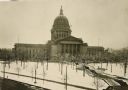
| Date: | 1930 |
|---|---|
| Description: | Elevated view of the west wing of the Wisconsin State Capitol building. A view of the fourth capitol with snow flocked trees and snow-covered lawn and side... |

| Date: | 1851 |
|---|---|
| Description: | Plat map of the Town of Madison (Township 7N, Range 9E), from Volume 4, Federal Survey Plat Books. |
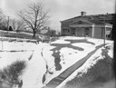
| Date: | |
|---|---|
| Description: | A turtle effigy mound on the University of Wisconsin-Madison campus, outlined by melting snow. |

| Date: | 1861 |
|---|---|
| Description: | Drawn the first year of the Civil War, this colored 1861 map of Dane County shows its towns, cities and lakes. It includes insets of the wards of Madison a... |
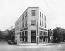
| Date: | 05 20 1930 |
|---|---|
| Description: | The Montgomery Ward Store Building at 100 North Hamilton Street, at the intersection of Pinckney and North Hamilton Streets. The building was designed by L... |
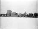
| Date: | 12 18 1955 |
|---|---|
| Description: | Downtown Madison lakeshore taken from Lake Monona in line with South Pinckney Street. Includes St. Raphael's steeple, 1 West Wilson Street state office bui... |

| Date: | 05 09 1908 |
|---|---|
| Description: | Kite aerial panoramic photograph of the central business district. In the distance is Lake Mendota. The fire damaged Wisconsin State Capitol is in the cent... |

| Date: | 1839 |
|---|---|
| Description: | A map of the Wiskonsin [sic] and Neenah or Fox Rivers. |

| Date: | 08 12 1932 |
|---|---|
| Description: | RKO motion picture actress Raquel Torres christening the new model airplane manufactured in Madison by Orland Corben. Corben had flown the airplane that br... |

| Date: | 10 30 1915 |
|---|---|
| Description: | Eighty-five Nakoma lot buyers enjoy a picnic in Nakoma, an outlying residential district. A quote on the print reads, "Go westward and grow up with Nakoma"... |

| Date: | 1904 |
|---|---|
| Description: | Monona Bay from the railroad trestle looking southwest, close to where the railroad tracks cross North Shore Drive, (now Brittingham Park), with old houses... |

| Date: | 1897 |
|---|---|
| Description: | A view from the capitol looking west up State Street toward the University of Wisconsin-Madison with the Holy Redeemer Church, Holy Redeemer School, Red Gy... |

| Date: | 1879 |
|---|---|
| Description: | Bird's-eye view of Wisconsin State University, now the University of Wisconsin-Madison. Vignettes include Ladies Hall, South Dormitory, University Hall, As... |

| Date: | 1885 |
|---|---|
| Description: | Bird's-eye map of Madison, State Capital of Wisconsin, County Seat of Dane County, with inset of the Wisconsin State Capitol. |

| Date: | 1852 |
|---|---|
| Description: | Pencil drawing of Madison landscape as seen from University Hill. The main street in the center is State Street, and the building with Greek columns in the... |

| Date: | 1852 |
|---|---|
| Description: | Pencil drawing of view overlooking Madison. The sketch looks down North Hamilton Street from the capitol. Rutted, irregular streets and frame houses mark ... |

| Date: | 1836 |
|---|---|
| Description: | The top map is the "Plat of Madison the Capitol of Wisconsin." The bottom map is the "Map of the Four Lake Country. Taken from the Township Maps in the U.S... |
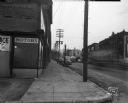
| Date: | 01 08 1946 |
|---|---|
| Description: | View down sidewalk along East Wilson Street at the corner of the South Hancock intersection looking toward the West Wilson Street-King Street intersection.... |
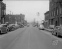
| Date: | 01 08 1946 |
|---|---|
| Description: | East Wilson Street scene looking northeast, taken at site of Reynolds Bus accident. Businesses shown include R & R Cafe at 316 East Wilson Street, Dizon Me... |
If you didn't find the material you searched for, our Library Reference Staff can help.
Call our reference desk at 608-264-6535 or email us at: