Filter: Categories of Wisconsin Historical Images
Filter: Subject of Land
Filter: Community of Jefferson
Filter: Categories of Wisconsin Historical Images
Filter: Subject of Land
Filter: Community of Jefferson

| Date: | 1870 |
|---|---|
| Description: | Although the first European settlement in Jefferson was in 1836, the Village of Jefferson was first incorporated as a city in 1878. Made eight years earlie... |

| Date: | 1893 |
|---|---|
| Description: | Bird's-eye map of Jefferson, looking north. Crayfish River at left and center, Rock River from upper center to bottom center, joins at left of center; thir... |
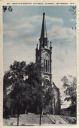
| Date: | 1910 |
|---|---|
| Description: | View towards the church on a hill. There is a wide set of stairs that leads up to the entrance. Caption reads: "St. John-the-Baptist Catholic Church, Jeffe... |
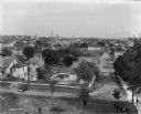
| Date: | |
|---|---|
| Description: | Elevated view of the town, probably from the west bank of the Rock River. Pedestrians are walking through a park in the foreground. |

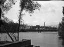
| Date: | |
|---|---|
| Description: | View of a dam on Rock River. Commercial buildings are visible in the background. |

| Date: | |
|---|---|
| Description: | View of the Rock River featuring a shoreline across the river with several buildings (possibly industrial plants), two towers, and many trees. |
| Date: | |
|---|---|
| Description: | View of the Old Toll Bridge with trees and a pier in the foreground and buildings on the opposite shore. |

| Date: | |
|---|---|
| Description: | View of the Old Toll Bridge with buildings standing on the opposite shore. |

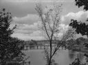
| Date: | |
|---|---|
| Description: | View of a bridge with a boat passing beneath it. Several dwellings are visible in the background. |

| Date: | |
|---|---|
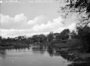
| Description: | River scene with views of the tree-lined shores. |

| Date: | |
|---|---|
| Description: | A boat is moored along a shore of a river lined with trees and dwellings. |

| Date: | |
|---|---|
| Description: | A boat rests along the shoreline of a river and town buildings are visible in the background on the opposite bank. |
| Date: | |
|---|---|
| Description: | Trees, other foliage, and several dwellings surround the shores of Crawfish River. |
| Date: | |
|---|---|
| Description: | A bridge crosses the Crawfish River. A dwelling stands along the tree-covered shoreline. |

| Date: | |
|---|---|
| Description: | Bundles of a harvested grain stand in a field beyond a body of water. |

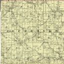
| Date: | 1887 |
|---|---|
| Description: | This map shows landownership, lot and block numbers, wards, cemeteries, and the high school. The map has been removed from Page’s Atlas of Jefferson County... |
If you didn't find the material you searched for, our Library Reference Staff can help.
Call our reference desk at 608-264-6535 or email us at: