 Filter: Categories of Wisconsin Historical Images
Filter: Subject of Land
Filter: Community of Janesville
Filter: Categories of Wisconsin Historical Images
Filter: Subject of Land
Filter: Community of Janesville

| Date: | 1877 |
|---|---|
| Description: | Bird's-eye map of Janesville on the Rock River. |

| Date: | 1920 |
|---|---|
| Description: | Elevated view of the old High School building. Caption reads: "Bird's-Eye View, from Old high School Building, Janesville, Wis." |
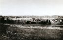
| Date: | 1893 |
|---|---|
| Description: | View from the south, with a railroad in the foreground, a river in the middle distance, and Janesville in the background. |

| Date: | 1853 |
|---|---|
| Description: | Map covers area between the cities of Janesville and Kenosha in Rock, Walworth, and Kenosha counties for railroad routes. Lakes and counties are labelled. ... |

| Date: | 1873 |
|---|---|
| Description: | This map shows landownership and acreages, lot and block numbers, roads and railroads, marshes, schools, churches, mills, rural buildings, and quarries. Re... |

| Date: | 1955 |
|---|---|
| Description: | This map includes a street index and shows municipal golf course, parks, schools, cemeteries, Janesville County Club, and industrial sites. The back of the... |

| Date: | 1900 |
|---|---|
| Description: | This map includes an index of streets and schools, and shows parks and public lands, as well as industrial sites. |

| Date: | 1973 |
|---|---|
| Description: | This map includes an index of streets and schools and also shows parks, schools and public lands, and industrial sites. Portions of the map are in green an... |

| Date: | 1900 |
|---|---|
| Description: | This map is indexed and shows numbering system, public buildings and parks, wards, and voting booths. |

| Date: | 1908 |
|---|---|
| Description: | Elevated view of the skyline of central Janesville and surrounding landscape. Caption reads: "Bird's Eye [sic] View of Janesville, Wis." |

| Date: | |
|---|---|
| Description: | View across street towards the Parker Pen Factory, with a large, electric sign on the roof. Caption reads: "Parker Pen Company, Janesville, Wis." |

| Date: | |
|---|---|
| Description: | Front of postcard envelope, with a scene of children on top of Big Rock Monterey on the Rock River. Inside the envelope is an accordion-folded set of vario... |

| Date: | |
|---|---|
| Description: | Elevated view of the Rock River. In the foreground is a man standing on railroad tracks. Janesville is on the far shoreline. There is a bridge in the dista... |

| Date: | |
|---|---|
| Description: | Elevated view of a curving railroad bridge with a train approaching. The Rock River is below. Buildings are on the far bank on the right. Caption reads: "C... |

| Date: | 1907 |
|---|---|
| Description: | View of Monterey Rock from the Rock River. There is a cave in the center, and a bridge in the distance. |
If you didn't find the material you searched for, our Library Reference Staff can help.
Call our reference desk at 608-264-6535 or email us at:
